|
||

|

|
|

|
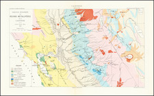
Colossal oil and gas map of Montana, compiled by J.D. Vine and C.E. Erdmann in 1952, revised by H.R. Smith in 1954, and published by the U.S.G.S. in 1956.
The map shows the entirety of Montana and, as of the mid-1950s, its oil and gas fields, pipelines, and anticlinal axes. There is further geological detail rendered as illustrations of pre-Cambrian and Tertiary-Cretaceous outcrops.
Specific symbols are used to differentiate between drilling wells, dry holes, dry holes with a show of oil, dry holes with a show of gas, dry holes with a show of oil and gas, producing oil wells, and producing gas wells.
Since the publication of this map, oil and gas exploitation has increased substantially, particularly in the northeast quadrant of the state.
The map might have been updated as part of the founding of the Oil and Gas Conservation Commission of the State of Montana, which commenced operations in 1954.
Oil was discovered in Montana in 1892, but production was not commercially viable until 1915 (or 1916; sources vary). Production in Montana has gone through several boom-bust cycles, the first of which was in the 1920s, followed by another period during World War II.