|
||

|

|
|

|
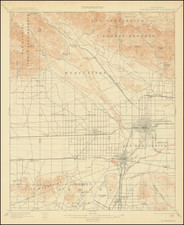
Oil in Beverly Hills.
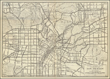
Highly detailed large format map of Los Angeles, with a focus on the oil-producing regions between Beverly Hills and the coast.
The map extends from Hollywood and Sherman in the North to Inglewood in the South and from Los Angeles to Santa Monica. Dozens of oil companies and individual land owners are named, including Ida Hancock, Rancho La Brea Oil Col, Amalgamated Oil Co., Union Oil Co., Francis Rampau Heirs, James H. Whitworth, John Wolfskill, So. Cal. Edison Co., John J. Charnock, Joseph Burkhard, Alonzo Whitaker, George Charnock, Frederick Rindge, J.J. Charnock, Jacob Brown, the Pennsylvania Oil Co., Guirado & Stevens, and many others.
The map identifies Rancho Rodeo de la Aguas, Rancho San Jose de Buenos Aires, Rancho Las Cienegas, Rancho Rincon de los Bueyes, Rancho Paso de la Tijera, Rancho la Ballona, and Rancho Aguaje de La Centinela.
The Los Angeles Country Club, Los Angeles Pacific Rail Road, and several other landmarks are noted. A key at the bottom identifies various types of rigs, drills, and other oil installations.
The Beverly Hills Oil Field
One of the nation's most famous oil fields, the Beverly Hills oil fields earned its notoriety from the ritzy land under which it sits. The oil is about 2,000 meters below the surface and was discovered early in the history of Los Angeles oil, in 1900. The eastern portion of the field has historically been the most productive, as seen on the present map. The Beverly Hills Oil Field neighbors the Salt Lake Oil Field, which was discovered slightly earlier and reached peak production in 1908. This oil field has been economically depleted and is no longer the site of drilling today.
Rarity
This map exists in an earlier 1919 edition, which does not mention the Beverly Hills Oil fields (it only names the Salt Lake Oil Field in the title). OCLC locates no examples of the 1921 edition of this map. It locates two examples of the 1929 edition and a single example of the 1930s edition.