|
||

|

|
|

|
Wall Maps Fit For A King. Owned by King Louis-Philippe I. With Brué's Important Map of North America.
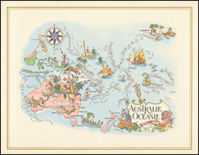
Fantastic set of five engraved wall maps of North America, South America, Africa, Asia, and the Pacific, prepared uniformly and housed in a contemporary box, first owned by Louis-Philippe I, King of France.
Adrien-Hubert Brué was one of the premier mapmakers of the middle of the 19th century, and his large-format maps of North America, which were issued between the 1810s and 1870s, provide an important picture of the authoritative mapping of the interior of that continent during a time of rapid discovery and change.
Perhaps the next-best map in the set is Brué's Carte Encyprotype de L'Afrique, which reflects the early-to-mid 19th-century approach to mapping Africa, removing almost all information that had not been corroborated by first-hand results. This commitment to empirical mapmaking erased most of the interior of Africa at the beginning of the century and established the target regions for European exploration throughout the century.
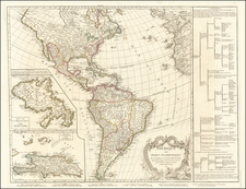
Brué's North America
The star of this set is Brué's rare and important map of North America from 1843. This large map illustrates the state of geographical knowledge on the eve of the Oregon Question, Texas Annexation and the Mexican War.
Brué's map of North America is a landmark map in North American history. The first edition of the map (1833) was the first map to incorporate information derived from Jedediah Smith. This 1843 edition moves past Smith's cartography in the West, presenting the picture of the west available at the time of John C. Fremont's first expedition to the West in the Summer of 1842.
Texas is shown as a republic, with many early roads, including the Comanche Trail ("Chemin de Comanches"), silver mines west of Austin, and early settlements.
In New Mexico, the Rio de La Norte (Rio Grande) extends into modern Colorado, with dozens of place names given. The region is traversed by the Spanish (Santa Fe) Trail and Pawnee Trail.
The Mandan and Osage Districts are separated by the "Ne-Brasca R. ou R. Plate", which finds its source at "Big Horn," in modern-day Colorado.
The course of the Missouri River is quite well executed, with its many tributaries reaching the Montagne Rochuses ou Oregon (Rocky Mountains).
"Nouvelle Californie" is a narrow band of land extending from the San Diego area to "R. Slawinska Ross" the fort established by the Russians near Drake's Bay. The chain of Spanish Missions in California is shown along the so-called Camino Real, extending from central Baja California through the missions of Upper California and reaching San Francisco Bay.
East of San Francisco Bay, the R. Jesus Maria flows speculatively from "L. Teguayo" to San Francisco Bay, with the Rio Sacramento now shown in its more true course rather than flowing from the Great Salt Lake (formerly called Lake Timpanago). A Fur Trading Depot appears east of the Great Salt Lake.
In Oregon Territory, Ft. Umpqua is shown on the Pacific Coast, along with Astoria, Ft. Vancouver, Ft. Nez Perces on the "Oregon ou Grosse R." (Columbia River). Further north, Ft. Stuart, Ft. Colville, Ft. Okanagan, Ft. Thomson, Ft. Langley, Ft. de la Prairie, and a number of Fur Depots of the Northwest Company are shown.
In the area of Puget Sound, Whidbey Island is shown named, along with a host of other place names.
Along the course of what would become the Northwest Passage, the coastline north of Alaska is now well delineated, but further east, a vast "Region Inconnue" is shown, pre-dating Franklin's fateful entry into the region and subsequent discovery of the Northwest Passage over the course of the next 15 years.
Rarity of the North America Map
The map is extremely rare. We note the following in OCLC:
- 1833: 2 copies, BnF and Wurttembergish Landesbibliothek (we have previously sold the 1833 once)
- 1835: 1 copy, Yale
- 1838: 1 copy, Bibliotheque et Archives Nationales du Quebec (digital image)
- 1840: 1 copy, UC Berkeley (Bancroft)
- 1843: 1 copy, Mediatheque de Montpellier (we have previously sold the 1843 edition twice)
- 1863: 1 copy, British Library
- 1872: 1 copy, University of Chicago
- 1874: 1 copy, University of Chicago
- 1877: 1 copy, British Library
Andre Hubert Brué was a French geographer and cartographer. Born in Paris, he served in the French Navy, joining the Baudin expedition to the Pacific (1800-1804). After his sea service, Brué applied his navigation and charting skills to creating finely-crafted maps, which were renowned for their crisp engraving and accuracy. He drew directly on the copper of the plate, creating what he called encyprotypes. He is best known for the Atlas universal de géographie physique, politique, ancienne et moderne.
![(Early Photographic Facsimile of the Mappamundi of Tunuslu Hajji Ahmed) Kemãl ile Naks Olinmis Cümle-I Cihãn Nemunesi [Fully Illustrated Exposition of the World in Its Entirety]](https://storage.googleapis.com/raremaps/img/small/66562.jpg)