


|
||

|

|
|

|
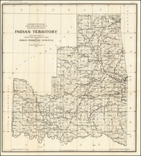
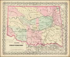
Fine example of Colton's map of Indian Territory, the earliest obtainable map of Indian Territory to appear in a Commercial Atlas.
The map is colored by Indian Nations, and shows a massive Cheyennes and Arapahoes Nation at the top, with 11 other nations named. Many references to treaties are shown, along with early towns, forts, settlements, roads and other details.
The map outlines the various boundaries of several Native American nations, including the Choctaw, Cherokee, Creek, Chickasaw, and Seminole, each distinguishable by different colors.
In addition to the tribal territories, the map shows early railroads, military posts, and stage routes that were indicative of westward expansion during this period. Existing towns and settlements are also represented, along with topographical features such as rivers, mountains, and forests.
This 1872 map of the Indian Territory by J.H. Colton provides a detailed representation of the area at a time of significant change in its cultural, social, and geographical structure. It is a historical artifact that offers a glimpse into American history at that time.
An essential map for Indian Territory collectors.
G. W. & C. B. Colton was a prominent family firm of mapmakers who were leaders in the American map trade in the nineteenth century. The business was founded by Joseph Hutchins Colton (1800-1893) who bought copyrights to existing maps and oversaw their production. By the 1850s, their output had expanded to include original maps, guidebooks, atlases, and railroad maps. Joseph was succeeded by his sons, George Woolworth (1827-1901) and Charles B. Colton (1831-1916). The firm was renamed G. W. & C. B. Colton as a result. George is thought responsible for their best-known work, the General Atlas, originally published under that title in 1857. In 1898, the brothers merged their business and the firm became Colton, Ohman, & Co., which operated until 1901, when August R. Ohman took on the business alone and dropped the Colton name.