
This item has been sold, but you can enter your email address to be notified if another example becomes available.


|
||

|

|
|

|
Stock# 90105
Description
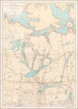
19th Century Map of Lake Superior.
Fine early map centered on Lake Superior, first published by the Society for Diffusion of Useful Knowledge in 1832.
This is one the earliest maps to focus on Lake Superior in great detail.
Includes depths, Indians, villages, rivers, islands towns and geographical notes.
An essential map to any Great Lakes collection.
![[ Great Lakes - Upper Midwest -- Western Canada ] Partie Occidentale Du Canada, contenant les cinq Grands Lacs, avec Pays Circonvoisons](https://storage.googleapis.com/raremaps/img/small/98377.jpg)
![[Ashland Wisconsin]](https://storage.googleapis.com/raremaps/img/small/60288.jpg)
![[ The Old Northwest Territory ] Il Paese De Selvaggi Outagamiani, Mascoutensi Illinesi E parte Delle VI Naxioni](https://storage.googleapis.com/raremaps/img/small/75927.jpg)