


|
||

|

|
|

|
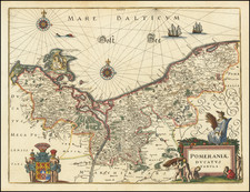
Karte von Kurland angefertiget und mit Allerhöchter Genehmigung herausgegeben von dem Kurl. Gouvernements Revisor und Ritter C. Neumann, published in Mitau (Jelgava, Latvia) in 1833 by Verlag von G.A. Reyher and lithographed by B. Herder in Freiburg im Breisgau, Germany, is a large and finely executed map of Courland (corresponding to present-day Latvia), dissected and mounted on linen, featuring a view of the Riga waterfront at the bottom. The map includes details such as towns, pastoral lands, water stations, forests, roads, marshes, and administrative boundaries, with an accounting of specific areas in the region of Courland.
The publication of this map coincides with a period of geopolitical stability and administrative organization in the Baltic provinces, of which Courland was a part. Under the Russian Empire, the early 19th century saw efforts to map and manage the territories with greater precision. The map serves as a testament to these efforts, reflecting the governmental interest in Courland's geographical, administrative, and infrastructural details. The inclusion of the view of the Riga waterfront adds an artistic element that connects the abstracted cartography with a tangible visual experience of the region's most significant city, which is, not incidentally, also at the center of the map.
The technical execution of the map, with its lithographed details, demonstrates the advancement of cartographic techniques during this era. The specific legend, labeling, and categorization present a meticulous understanding of Courland's geography, emphasizing the elements that would have been of particular interest to administrators, landowners, and those involved in local governance. The measurements and delineations of different areas further illustrate the map's focus on quantitative accuracy.
Karte von Kurland stands as an important historical artifact of 19th-century Courland, encapsulating both the region's unique geographical attributes and the broader administrative context within the Russian Empire. By merging the scientific accuracy of its cartographic representation with the aesthetic appeal of its design, this map provides a rich and multifaceted window into Courland's landscape and historical milieu. It embodies a confluence of artistic and scientific principles, reflecting the broader European intellectual and cultural currents of its time.
Rarity
Rare. No copies are recorded in RBH nor in OldMaps.com. OCLC records examples at the BnF, Herder Institut, and the Bibliotheque Nat & Univ Strasbourg, to this we can add the National Library of Latvia.
![[ Ethnographic Thematic Atlas - Poland, Lithuania, Ukraine, etc. ] Völker-Verteilung in West-Russland (Distribution of Peoples in Western-Russia)](https://storage.googleapis.com/raremaps/img/small/94045.jpg)