|
||

|

|
|

|
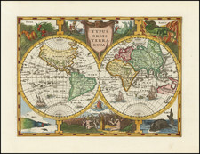
A Tour de Force of Decorative 17th-Century Cartography.
Blaeu’s Monumental Map of Europe—Rare Italian Edition--with Very Early Appearance of 1644 Tasman Discoveries in Australia
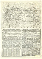
Stunning example Blaeu’s famous, and exceedingly rare, wall map of Europe, with a large inset world map, one of the earliest maps to show Abel Tasman voyage of 1644.
Published in Venice in about 1646 by Stefano Scolari, this is the earliest example of the map published outside of Amsterdam, the present example being a virtually unknown early state.
The map includes a number of marvelous elements, including a massive mythical island of Frisland immediately west of Iceland, a number of beautifully executed costumed figures showing regional European finery, and, most historically notable, a depiction of Nova Hollandia which only began to appear on Blaeu's own wall maps of 1645 and 1646, noting the discoveries made by Dutch explorer Abel Tasman on his 1644 voyage which greatly expanded the European knowledge of the Australian continent.
First published in about 1609, Blaeu’s original map of Europe was, at the time of publication a monumental work of visual artistry. His first set of maps were issued in 1608 and 1609, a wall map of the World, the four continents and the Holy Roman Empire, all of which are considered unobtainable by collectors and typically surviving in 1 or 2 known examples in institutional collections. Beginning with the present map of 1646, several Italian and French publishers made close copies of the original Blaeu wall maps, with the present example being the earliest known example.
The present map is a spectacular example of the grand genre of wall, or parlor, maps that enjoyed an iconic place in 17th and early 18th-century Europe. At the pinnacle of this genre were the maps of the Blaeu family, generally regarded as the finest wall map makers of the Golden Age. Large, highly decorative and expensive productions, they were considered to be the ultimate signs of wealth and intellectual sophistication. In this vein, Blaeu wall maps appeared prominently in works of fine art, most notably the paintings of Johannes Vermeer. Displayed in the salons of leading merchants and noblemen, the maps were especially prone to damage and their survival rate is extremely low, especially in this condition.
Scolari's map very closely follows the second state of Blaeu's map issued in 1612, engraved by Josua van den Ende with decorative elements engraved by Hessel Gerritz. Scolari's engraved work was so exact that many of the decorative elements are nearly identical. Later Italian editions were themselves derived from Scolari's work.
Cartography
The cartography derives from Willem Janszoon Blaeu's1608-9 wall map of Europe, part of a set of four continental wall maps which would inspire reduced size single sheet maps of the four continents, first issued separately and later appearing after 1630 in the Blaeu firm's many atlas productions throughout the 17th century. The coastlines of Europe are, in general, correct and based on current accounts from Dutch navigators, although the east-west extent of the Mediterranean is slightly exaggerated, as per usual.
Iceland appears following the geography shown on the 1595 Mercator atlas map, which corrects some of the issues present in Ortelius's map and derives from Bishop Gudbrandur Thorlaksson's map. The mythical island of Frisland appears and is populated with several small towns. Russia also derives from Mercator's atlas map of the region, with the associated errors to the path of the Volga still present.
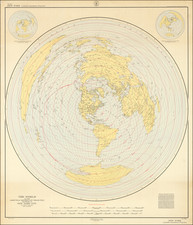
As noted above, the inset World map is of significant note, appearing in the same years as several Blaeu Wall maps of the World which include a note announcing Abel Tasman's discoveries of 1644.
City Views
The map includes twelve city views along its base, showing London, Paris, Lisbon, Toledo, Rome, Venice, Amsterdam, Nuremberg, Prague, Vilnius, Moscow, and Constantinople. Ten of these views are based on the maps produced by Braun and Hogenberg for their Civitates Orbis Terrarum. The Prague view is based on a 1601 woodcut map produced by Johann Willenberg. The Amsterdam town plan is based on Blaeu's own earlier map, produced from first-hand sources.
Discussion Regarding the Prime Meridian
The map includes a lengthy description below the world map discussing the reason for placing the prime meridian at the Pico in Tenerife. This inset is important for its discussion of the longitude problem. Bleau discusses the idea favored by some Dutch mapmakers, including Petrus Plancius, that longitude could be determined from the declination of a compass needle. This idea, however, was repudiated by navigators who sailed farther abroad at the end of the 16th and start of the 17th centuries, which Blaeu mentions.
The Scolari Edition and States
Guenter Schilder says of the Scolari derivatives:
The copying in Venice was done very professionally: differences can be noted only through a close comparison with Blaeu's originals. The Italian copyist imitated his models in every detail, and the decorative borders. Even the engraver's name on Blaeu's map of Africa was copied. Small differences are visible only in the long legends in the cartouches: apparently the Italian engraver did not succeed in engraving the same number of words in the space available nor with the regularity of the letters.
There are some identifiable state differences between the known examples of this map. We are aware of later state with an imprint appearing in the lower right cartouche, which is blank here. Schilder's description of the Scolari edition is unclear as to whether there are any further state differences. The dating of the map comes from an example of the map held by the University of Perugia that is accompanied by text dated 1646.
Rarity
All versions of Blaeu's wall map of Asia are virtually unobtainable.
The original Blaeu map is only known to exist in seven examples across all states, according to Schilder. Schilder lists examples of the Scolari at Perugia, LOC, Greenwich National Maritime Museum (two examples), and UT Austin.
Willem Janszoon Blaeu (1571-1638) was a prominent Dutch geographer and publisher. Born the son of a herring merchant, Blaeu chose not fish but mathematics and astronomy for his focus. He studied with the famous Danish astronomer Tycho Brahe, with whom he honed his instrument and globe making skills. Blaeu set up shop in Amsterdam, where he sold instruments and globes, published maps, and edited the works of intellectuals like Descartes and Hugo Grotius. In 1635, he released his atlas, Theatrum Orbis Terrarum, sive, Atlas novus.
Willem died in 1638. He had two sons, Cornelis (1610-1648) and Joan (1596-1673). Joan trained as a lawyer, but joined his father’s business rather than practice. After his father’s death, the brothers took over their father’s shop and Joan took on his work as hydrographer to the Dutch East India Company. Later in life, Joan would modify and greatly expand his father’s Atlas novus, eventually releasing his masterpiece, the Atlas maior, between 1662 and 1672.
Stefano Scolari was active between 1644 and 1687. He was a designer, engraver and editor from Brescia, although he practiced his trade in Venice. His shop, in S. Zulian under the sign of the Three Virtues, was one of the best known in seventeenth-century Venice. He engraved, printed, and traded in prints, particularly, maps. He specialized in the re-issue of important maps including Gastaldi's map of Lombardy and the 12-sheet map of Italy by Greuter.
![La Sphere Artificielle . . . 1740 [Terrestrial, Celestial & Armillary Globes]](https://storage.googleapis.com/raremaps/img/small/80300.jpg)