|
||

|

|
|

|
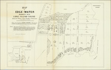
Stock# 87284
Description
New York City at the Center of the World.
Post-World War II U.S. government wall map of the world on an Azimuthal Equidistant Projection intended to show the distances from New York City to the rest of the world.
Map projections such as this one became important with the advent of long-range airplane travel, jet aviation, and long-range ballistic missiles. Various bodies of the United States government produced them after World War II to help better illustrate the nature of transcontinental Great Circle travel, for airplane route planning, etc.
Maps such as this one made judgments about the true distance from a single location more intuitive than those on the Mercator Projection.
![(World - First State!) Benedict Arias Montanus Sacrae Geographiae Tabulam ex Antiquissimorum Cultor. [Pre-Dutch Discovery Depiction of Australia]](https://storage.googleapis.com/raremaps/img/small/93232.jpg)

![[English Edition!] Nova Totius Terrarum Orbis Geographica Ac Hydrographica Tabula Auct. Henr: Hondio. . . . 1630](https://storage.googleapis.com/raremaps/img/small/78002.jpg)