|
||

|

|
|

|
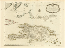
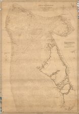
Fine detailed plan of the island of Hispaniola, first published by Guillaume De L'Isle.
The "Carte de l'Isle de Saint Domingue" is a map of the island of Hispaniola published in 1725 by the Parisian mapmaker Guillaume Delisle. The map's title translates to "Map of the Island of Saint Domingue Drawn in 1722 for the Use of the King Based on the Memoirs of Mr. Frezier." The map shows the entire island of Hispaniola, as well as the neighboring Bahamas.
In the 1720s, the history of Hispaniola was closely tied to that of its western half, which was known as Saint-Domingue and would later become the independent nation of Haiti. At the time, Saint-Domingue was the most profitable French colony in the New World, thanks to its extensive sugar plantations and the labor of enslaved Africans. The map's inclusion of the Bahamas is likely due to the close trade and political ties between the two regions.
The Bahamas, meanwhile, had a long history dating back to the early 16th century, when they were inhabited by the Lucayan people. In the 1720s, the Bahamas were a British colony and an important center of the Atlantic slave trade. The map's depiction of the Bahamas suggests their strategic importance as a waypoint for ships traveling between Europe and the Caribbean. Overall, the "Carte de l'Isle de Saint Domingue" provides a valuable snapshot of the political and economic landscape of the region in the early 18th century.
Guillaume De L'Isle (1675-1726) is probably the greatest figure in French cartography. Having learned geography from his father Claude, by the age of eight or nine he could draw maps to demonstrate ancient history. He studied mathematics and astronomy under Cassini, from whom he received a superb grounding in scientific cartography—the hallmark of his work. His first atlas was published in ca. 1700. In 1702 he was elected a member of the Academie Royale des Sciences and in 1718 he became Premier Geographe du Roi.
De L'Isle's work was important as marking a transition from the maps of the Dutch school, which were highly decorative and artistically-orientated, to a more scientific approach. He reduced the importance given to the decorative elements in maps, and emphasized the scientific base on which they were constructed. His maps of the newly explored parts of the world reflect the most up-to-date information available and did not contain fanciful detail in the absence of solid information. It can be fairly said that he was truly the father of the modern school of cartography at the commercial level.
De L’Isle also played a prominent part in the recalculation of latitude and longitude, based on the most recent celestial observations. His major contribution was in collating and incorporating this latitudinal and longitudinal information in his maps, setting a new standard of accuracy, quickly followed by many of his contemporaries. Guillaume De L’Isle’s work was widely copied by other mapmakers of the period, including Chatelain, Covens & Mortier, and Albrizzi.
![[Saint-Marc, Haiti] Plan de la Ville de St. Marc, dans l'Isle St. Domingue . . . 1785](https://storage.googleapis.com/raremaps/img/small/88259.jpg)