


|
||

|

|
|

|
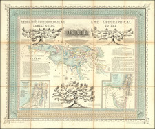
Rare and impressive map celebrating the second year of Israel's founding, published by Joseph Shapiro in Tel Aviv.
The map is remarkable for its Social Realist style, apparent in the hard-faced figures lining the left and the right of the map. Some figures are shown hard at work in industrial and agricultural pursuits, while others are shown waving an Israeli flag and hanging a menorah plaque. These scenes were designed by the artist and sculptor Michael Karra.
The map shows the recognized boundaries of Palestine, the armistice line, and the boundaries proposed in the 1947 partition plan. The geography is very detailed, with topography, place names, boundaries, roads, and other features are shown throughout.
We have previously handled The Third Year of the State of Israel.
![[Jerusalem's Two Hills] Hierosolyma, Clarissima Totius Orientis Civitas Iudaee Metropolis . . .](https://storage.googleapis.com/raremaps/img/small/74099.jpg)
![(Czech Edition) Tabule a wymalovánj země Swaté [Map of the Holy Land]](https://storage.googleapis.com/raremaps/img/small/93473.jpg)