|
||

|

|
|

|
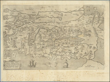
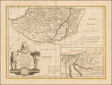
Historic Jerusalem and Its Two Hills
Striking early plan of Jerusalem, from Braun & Hogenberg's Civitates Orbis Terrarum, the most famous and influential book of town plans published in the 16th Century.
The image is a meticulously detailed historical portrayal of Jerusalem, the renowned metropolis of the East. The map encapsulates a historic topography, inviting the viewer to step back into a time where this renowned city was etched and hewn into the very stones of its two principal hills.
With a bird's eye perspective, the map reveals the complexity and grandeur of Jerusalem, unfolding a tale of an illustrious city divided and yet united by its topography. The two higher hills rise above the landscape, presiding over a maze of human habitation. These hills, identified as Zion and the second unnamed hill, carry the richness of history within their contours.
Zion, the higher hill, is segregated into three distinct areas: Millo, the lower city, and the location of Herod's Palace. Millo, a fortress of antiquity, has the honor of being David's chosen place for the Ark of the Covenant, illustrating the divine aspect of this site. The lower city was once home to King David's palace, while the third area, the northern hill, cradles the remains of Herod's Palace. The map subtly delineates these three sites as the ‘City of David,’ enveloped by walls and steeped in the resonance of a storied past.
The second hill is divided into Mount Moriah and Acra, each carrying their unique narratives. Mount Moriah, steeped in religious lore, is the site where Abraham prepared to sacrifice his son Isaac. Solomon’s majestic temple, a beacon of Jerusalem's spiritual past, crowns this hill. To the south, Solomon's royal house is shown.
Acra, the other section of the second hill, stretches eastward into two parts: Bezerha and a suburb standing against the Kidron Valley. Bezerha, the 'new city,' is a portrayal of progress within ancient bounds, encompassed by protective walls. The suburb houses the Palace of the Ancients, a nod to the city's age-old past, adding depth to Jerusalem's historical narrative.
The three keys within the map serve as a guide, translating the symbols and markings that spread across the parchment like a tapestry of history and culture. They bridge the centuries, helping modern viewers navigate through the intricate details and landmarks, making the map a timeless conduit between past and present.
Finally, the map pays homage to its contemporary custodians, the Turks, who refer to this ancient city as 'Kudus.' This nod to the city's present identity brings the map's story full circle, beginning with the ancient roots of the Jebusites and closing with the modern stewardship of the Turks.
The title block of the map (top left) translates as follows:
Jerusalem, the most illustrious city of the East and a metropolis, was built upon two hills that were higher than all the others in the surrounding area. These two hills, separated by a valley densely populated with human habitations, were called Tyropoeon by Josephus in Book 6 of The Jewish War. The higher hill was named Zion, which itself was divided into three areas. The first area, known as 'Millo' in the Second Book of Kings, was located near Mount Zion. Here, the ancient fortress of Siloam was built, which was occupied by the Jebusites and later conquered by King David, who selected it as the site for the Ark of the Covenant and his burial place. It is believed that a Franciscan Monastery, also named 'Zion', was built at the same location.
However, towards the east of this aforementioned hill, there existed another area which was referred to as the 'lower city,' wherein David's palace was constructed. King David inhabited this place before he had seized the Jebusite fortress in Millo. To the north, there was a hill where Herod's Palace was situated. These three hills, encircled by walls, are referred to as the 'City of David.'
The second hill consisted of two sections, one called Mount Moriah, where Abraham offered his son Isaac, as referenced in Book 1, Chapter 14 of Josephus' Antiquities of the Jews. In this place, Solomon later built his temple, and on the slope of this same mountain towards the south, his royal house stood, which was named the 'Palace of Solomon.' This hill, notable for its temple, was also surrounded by walls and was annexed to the 'City of David.'
The other section of this hill was named Acra. Stretching towards the east, half of it or one part was named Bezerha, translating to the 'new city,' and was also enclosed by a wall. The other half or section of Acra, positioned against the Kidron Valley, contained the Palace of the Ancients and was a suburb, enclosed by walls. Thus, the aforementioned hills were each encompassed by four distinct walls. In modern times, the Turks refer to Jerusalem as 'Kudus'."
Georg Braun (1541-1622) was born and died in Cologne. His primary vocation was as Catholic cleric; he spent thirty-seven years as canon and dean at the church St. Maria ad Gradus, in Cologne. Braun was the chief editor of the Civitates orbis terrarum, the greatest book of town views ever published. His job entailed hiring artists, acquiring source material for the maps and views, and writing the text. In this role, he was assisted by Abraham Ortelius. Braun lived into his 80s, and he was the only member of the original team to witness the publication of the sixth volume in 1617.
Frans Hogenberg (ca. 1540-ca. 1590) was a Flemish and German engraver and mapmaker who also painted. He was born in Mechelen, south of Antwerp, the son of wood engraver and etcher Nicolas Hogenberg. Together with his father, brother (Remigius), uncle, and cousins, Frans was one member of a prominent artistic family in the Netherlands.
During the 1550s, Frans worked in Antwerp with the famous mapmaker Abraham Ortelius. There, he engraved the maps for Ortelius’ groundbreaking first atlas, published in Antwerp in 1570, along with Johannes van Deotecum and Ambrosius and Ferdinand Arsenius. It is suspected he engraved the title page as well. Later, Ortelius supported Hogenberg with information for a different project, the Civitates orbis terrarium (edited by Georg Braun, engraved by Hogenberg, published in six volumes, Cologne, 1572-1617). Hogenberg engraved the majority of the work’s 546 prospects and views.
It is possible that Frans spent some time in England while fleeing from religious persecution, but he was living and working in Cologne by 1580. That is the city where he died around 1590. In addition to his maps, he is known for his historical allegories and portraits. His brother, Remigius, also went on to some fame as an engraver, and he died around the same time as his brother.
![[Cyprus, Holy Land, Syria, Arabia] Tabula Asiae IIII (with) Tabula Asiae III on Verso [Armenia, Georgia etc.]](https://storage.googleapis.com/raremaps/img/small/88877.jpg)