|
||

|

|
|

|
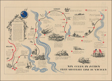
Colorful map of Germany illustrating its division by the Allies following the end of the Second World War.
The map shows the portions of pre-war Germany controlled by each of the allied powers, as well as the regions given to Poland. Flags are planted to indicate the control of each region. Rivers and cities are also shown.
The map was produced by the Service Géographique des troupes d'occupation en Allemagne, the French cartographic wing of the military occupation of Germany.
The Potsdam Conference and the Occupation of Germany
The Allied Powers (United States of America, France, United Kingdom, and the Soviet Union) met at the Potsdam Conference, held at the Cecilienhof Castle near Berlin, from July 17 to August 2, 1945.
During the conference, the Allies agreed to partition Germany. As shown on the map, large portions of East Prussia were given to Poland and the Soviet Union (the Königsberg, or 'Kaliningrad Enclave'). What remained of Germany was then divided into military sectors of influence, each under a different Allied Power. East Germany was placed under Soviet influence, while most of northern Germany was placed under British auspices. The lands bordering France were placed under her control, while the Americans assumed responsibility for Bavaria, Hessen and part of Württemberg. Berlin, located deep within East Germany, was then itself divided into sectors of control, with the Soviets overseeing East Berlin, while West Berlin was shared by the other Allied Powers.
The Potsdam Conference envisaged that free and fair elections would occur throughout a united Germany. However, the Soviets assumed dictatorial control over East Germany, and it separated to form its own Communist state. The rest of the nation came to form West Germany, a democracy with very limited intervention from the Allied Powers. The military zones of control were abolished in 1990 following German Reunification.
![[Denmark, Netherlands, Belgium, North Sea] Europ IIII Tab](https://storage.googleapis.com/raremaps/img/small/89170.jpg)
![Deutschland un die Niederlande von Bauerkeller [Germany and the Netherlands by Bauerkeller]](https://storage.googleapis.com/raremaps/img/small/88180.jpg)