|
||

|

|
|

|
Stock# 88180
Description
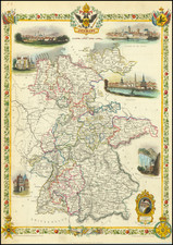
A handsome topographical map of Germany and neighboring regions, done by one of the mid-19th century's standout mapmakers, Georg Leonhart Bauerkeller.
The map is a fantastic example of Georg Leonhart Bauerkeller's capacity for detailed color composition and lithography. From 1844, Bauerkeller was involved in a series of looseleaf color-printed atlases, with Ludwig Ewald serving as the primary author from at least 1845.
Today the Bauerkeller atlases are quite rare, as are their maps. This is example is dated to 1844 based on a very similar map of Germany (without the topography) dated to that year by the BnF.
The BnF has his name as "Georg Michael Bauerkeller", whereas Rumsey gives it as "Georg Leonhart Bauerkeller."
Condition Description
Minor staining in the blank margins.
![[Course of the Rhine River] Corso del Reno Parte Septentrio [and] Corso del Reno Parte Meridionale . . . 1690](https://storage.googleapis.com/raremaps/img/small/73095.jpg)
![Hanc Ger[maniae et P]oloniae de[s ... ]em Serenissim [P]otentissimi Poloniae Regi August offert et inscribit Petrus Schenck](https://storage.googleapis.com/raremaps/img/small/64898.jpg)