


|
||

|

|
|

|
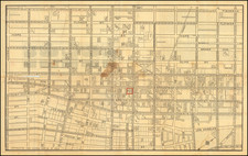
Oil Drilling in California's Orange County.
Scarce promotional map advertising the many benefits of Orange County in the immediate post-World War I period.
The base map, copyrighted 1916 and printed in red and orange, advertises the paved roads present in Orange County at the time. The map heavily promotes life in Orange County, with soil and oil production values for 1916-1920 shown at the bottom of the map and various slogans such as "Is the smallest in area in Southern California, and the richest County in soil Products in America." It further calls the county "Semi-Tropic" in climate. The verso of the map shows several early scenes of the county.
The development of Orange County at the time is still limited when compared to the present. The disjointed cities shown are Santa Ana, the largest, Anaheim, Fullerton, Huntington Beach, Seal Beach, Laguna, and San Juan Capistrano. Many cities such as San Clemente and Dana Point have yet to be shown. Roads go off the map to San Diego (US Highway 101), Elsinore (Ortega Highway), Riverside and San Bernardino (Santa Ana Canyon Road), Pomona (Brea Canyon Road), and many other destinations.
The map was copyrighted by George H Davis for the county surveyor at the time, J. L. McBride.

![[San Joaquin Valley] Valley of Kah Wee Ya River (Four Creeks)](https://storage.googleapis.com/raremaps/img/small/90289.jpg)
![[ Orange County / Wine Industry ] Residence of Theodore Reiser, Anaheim, Los Angeles Co., Cal.](https://storage.googleapis.com/raremaps/img/small/96403.jpg)