|
||

|

|
|

|
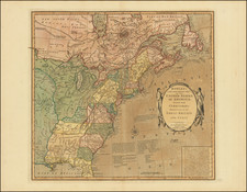
Mapping the Newly Independent States of America During The War
Fascinating map of the United States, published shortly before the conclusion of the American Revolution.
Engraved by John Lodge, the map illustrates the former British Colonies 3 years prior to the Treaty of Peace between United States, Great Britain, France and Spain, signed by the parties on January 20, 1783. Substantial topographical and other details are shown, including the locations of forts, towns, rivers, mines, land grants, borders between the colonies, and areas occupied by Native North American Tribes. The boundaries of the colonies/states are marked, including "Limits stipulated 1738", the southern "Bounds of Carolina by Charter 1665" along a parallel running approxmately through Daytona Beach, today in Florida, "Bounds of Virginia and New England 1609" running along the 40th Parallel, and "North Bounds of New England by Charter 1620" extending to the west of Lake Superior just south of the 48th Parallel.
The borders of the Granville Tract (named as "Earl Granville's Property") are delineated in the Carolinas. Granville refused to sell his lands to the Crown in 1728-9. He and his executors subsequently disposed of much of his property, while the remainder was taken by the new state of North Carolina in 1777 during the Revolution. The location "Walker 1750" is marked in what is now southern Kentucky, the location of the royal grant of land to the "Loyal Land Company" founded by the explorer Thomas Walker."
In 1783, the map would be reissued to show "The Rebel Colonies Now The United States of America".
Contents of the Map
This revised map identifies the following new regions, as established by the Preliminary Treaty of Peace which had been agreed on November 30, 1782, but only signed in Versailles on January 20, 1783 (and not approved by the American Congress of the Confederation until April 15, 1783). The revised edition inserts the new boundaries and identified the the newly acquired lands of each of the Treaty participants. https://www.raremaps.com/gallery/detail/44130
Rarity
Both states of the map are quite rare on the market.
![(Lasalle's Final Expedition) Dernieres Decouvertes dans L'Amerique Septentrionale de M. De La Sale [i.e., La Salle], Mises au jour par M. le Chevalier Tonti, Gouverneur du Fort Saint Louis, aux Islinois.](https://storage.googleapis.com/raremaps/img/small/69476.jpg)
![[ Catholic Dioceses and Missions in the United States ] Karte der katholischen Dioecesen und der en Missionen in Nordamerika nach den nuesten geographischen Angaben... 1845](https://storage.googleapis.com/raremaps/img/small/98630.jpg)
![[German Northern Pacific Promotional Tract] Die Nordliche Pacific Eisenbahn; Ihre Route, hulfsquellen, fortschritte & Gefchafte. der neue Nord-Westen und seine grosse Verkehrs-Strasse.](https://storage.googleapis.com/raremaps/img/small/83777.jpg)