|
||

|

|
|

|
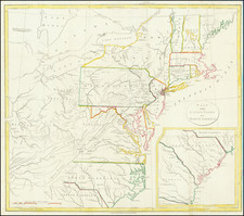
First Map To Name New Orleans -- "The Mother and Main Source of All the Later Maps" of the Mississippi River and Interior Parts of the United States
Second state of De L'Isle's seminal map, one of the most important and influential maps of the 18th Century.
This second state of De L'Isle's map is the first map to name New Orleans. La Nouvelle-Orleans was founded by Jean Baptiste Le Moyne de Bienville in the Spring of 1718, just before the first state of this map was published. The second state was published soon after the first, which was the first map to ever name Texas.
De L'Isle's map is one the most widely copied and influential maps ever produced. The map contains the indications of the explorations of De Soto, Cavelier, Tonty, Moscoso, and Denis throughout the Texas, the Midwest and Great Lakes regions, and was the first indication of the discoveries of the latter explorers. The map shows the best depiction of the Mississippi River to date, for the first time presenting a roughly accurate delineation of its entire length, as well as a semblance of accuracy about many of its tributaries. The appearance of the legend "Mission de los Teijas," indicating a mission established in 1716, makes the first state the first map to include the name that would become Texas. Regarding this, Martin & Martin state that for this contribution, "Delisle has received proper credit for establishing Texas as a geographic place name.”
As noted by Cohen:
"A significant map in Western American history and a work by one of the greatest mapmakers of all time. The map revealed for the first time the importance of the Missouri River and gave the most accurate delineation of the Mississippi Valley up to that time… [Delisle's] passion for pure scientific accuracy is reflected on his maps. If geographic information had not been directly observed by a reliable source, he refused to acknowledge it. Many longstanding myths and errors that had been passed from mapmaker to mapmaker for generations were suddenly absent on Delisle's maps."
The map stretches from Florida to Texas, and from the mouth the Rio Grande to the English colonies. Florida is shown in an archipelago configuration, while the English colonies are pressed against the coast, a provocative symbol of French power and cartographic propaganda. An extremely detailed inset shows the mouth of the Mississippi, highlighting the map's focus on that great river.
De L'Isle's rendering of Texas is a notable improvement over previous maps. The river system and coastline are much more accurate in this map and begin to take their modern form. Much of the information here comes from the expeditions of the French-Canadian soldier Louis Juchereau de St. Denis, one of the most important explorers of Spanish Texas. His route is marked on the map, alongside many other early exploreres.
A seminal map for Americana collectors.
Guillaume De L'Isle (1675-1726) is probably the greatest figure in French cartography. Having learned geography from his father Claude, by the age of eight or nine he could draw maps to demonstrate ancient history. He studied mathematics and astronomy under Cassini, from whom he received a superb grounding in scientific cartography—the hallmark of his work. His first atlas was published in ca. 1700. In 1702 he was elected a member of the Academie Royale des Sciences and in 1718 he became Premier Geographe du Roi.
De L'Isle's work was important as marking a transition from the maps of the Dutch school, which were highly decorative and artistically-orientated, to a more scientific approach. He reduced the importance given to the decorative elements in maps, and emphasized the scientific base on which they were constructed. His maps of the newly explored parts of the world reflect the most up-to-date information available and did not contain fanciful detail in the absence of solid information. It can be fairly said that he was truly the father of the modern school of cartography at the commercial level.
De L’Isle also played a prominent part in the recalculation of latitude and longitude, based on the most recent celestial observations. His major contribution was in collating and incorporating this latitudinal and longitudinal information in his maps, setting a new standard of accuracy, quickly followed by many of his contemporaries. Guillaume De L’Isle’s work was widely copied by other mapmakers of the period, including Chatelain, Covens & Mortier, and Albrizzi.
![[ Northern Pacific Railroad ] NEW 7-30 GOLD LOAN OF THE Northern Pacific Railroad Co. SECURED BY FIRST MORTGAGE ON RAILROAD AND LAND GRANT. SAFE! PROFITABLE! PERMANENT!](https://storage.googleapis.com/raremaps/img/small/101828.jpg)