|
||

|

|
|

|
With Map of Texas and the West: The Doniphan Expedition
The first German edition of Wislizenus's account of his tour to northern Mexico during which he joined Col. Doniphan's expedition. The English language edition was published at Washington in 1848.
Frederick Adolphus Wislizenus, a German-born medical doctor who came to the United States in 1835, set out on a self-funded scientific expedition into Texas, New Mexico and northern Mexico in 1839-1840. His stated purpose was "to gather information on the geography, geology, and natural history of northern Mexico and California." He left Independence, Missouri in May of 1846, following the Santa Fe Trail, just about the time of the declaration of war between Mexico and the United States. A U.S. Army detachment under General Stephen Watts Kearny pursued Wislizenus's caravan as a member of the group (Albert Speyer) was rumored to be carrying arms destined for the governor of Chihuahua. Near Santa Fe Wislizenus and his party were arrested and taken to Matamoros, where they were held for about six months. Wislizenus was released when Colonel Alexander Doniphan arrived on the scene with his regiment of Missouri Mounted Volunteers. He then joined Doniphan's regiment as a surgeon and remained attached with the outfit on the return trip to St. Louis.
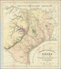
The book includes two folding maps and one folding profile. Wheat has singled out the largest of the two maps, which depicts Wislizenus's route, as being
...of considerable value... A number of routes to New Mexico and across Texas are shown, and Doniphan's campaign is carefully followed from Independence through New and old Mexico to the camp of June 2nd, 1847, at Reynosa, near the mouth of the Rio Grande
The titles of the maps and profile are as follows:
- Karte über eine Reise von Indepedence nach Santa Fe, Chihuahua, Monterey und Matamoros von A. Wislizenus, in den Jahren 1846 und 1847. 18 inches x 22.75 inches.
- A nicely detailed map showing all of the territory of present-day Texas. Numerous routes are depicted, including Josiah Gregg's Santa Fé route from 1840, the Texas Santa Fé Expedition route from 1841 and Gen. Wool's Route of 1846.
- Geologische Skizze.
- Profil der Erhebungen über der Merresfläche. Route von Independence Missouri nach Santa Fé. Route von Santa Fé nach Chihuahua. Route von Chihuahua nach Reynosa am Rio Grande.
At the time of this Texas-New Mexico-Chihuahua expedition Wislizenus was already a seasoned western traveler, having been part of a fur trading party in 1839 that made its way up the Oregon trail, across the Rockies to Idaho. That trip was described in a separate book, published in 1840.
Wislizenus closely observed the fauna, flora, and geology of the region and collected specimens...[he] was praised for its scientific observations by Alexander von Humboldt. In later life Wislizenus made excursions to Constantinople and to California - Hill.
Rarity
This German first edition is rare in the market, much more so than the English language edition.
![(Yosemite Photographs) [Contemporary Album of 12 Albumen Photographs of Yosemite Valley] Views in California [binding title]](https://storage.googleapis.com/raremaps/img/small/94232.jpg)
![Researches in Telephony [in] Proceedings of the American Academy of Arts and Science, Vol. 12](https://storage.googleapis.com/raremaps/img/small/86222.jpg)