|
||

|

|
|

|
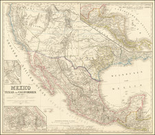
The First Geological Map of Texas and One of the Most Accurate Maps of the Time - Jenkins. By the Father of Texas Geology.
This is one of the great Texas maps: it is the first to show the state's geology, and it shows the results of one of the only scientific explorations undertaken in the Republic of Texas.
This map is important for several reasons. The delineation of geology is exceptional for a map of a Western state for this period. Donald C. Barton, a pre-eminent Texas geologist in his own right and the first geologist to use geophysical methods to identify an oil field, says of Ferdinand Roemer that "much of his geological observation and reasoning is just as good now and always will be as good as when he made them." The importance of geology to the state of Texas needs no explanation, and this map's role in opening the region to resource exploration makes it one of the most significant maps in Texas history.
Roemer's map is noteworthy as the first derivative of the 1845 James T.D. Wilson map of Texas. Wilson's map, the most accurate map of the Republic of Texas before its annexation, is here updated, particularly in the Texas Hill Country. West of Austin, we see numerous updates, including the appearance of "Friedrichsburg" and the corrected courses of rivers. Roemer also shows the route of his traverse of the region now partially submerged under Lake Travis. The map shows an early appearance of Dallas.
James Frank Dobie says of Roemer's time in Texas that he "saw more and told more about [Texas] . . . than anyone between Cabeza de Vaca and Frederick Law Olmsted." This is evident in the detailed nature of the map. Five types of geological strata are shown, including granite, chalk, Paleozoic rocks and coal seams, tertiary rocks, and alluvial deposits. Roemer maps the Cross Timbers to show the transition between mixed pine and deciduous forests to deciduous-dominated forests. The delimitation of topography in the Texas hill country is very clear and an improvement on Wilson's map.
This is an important map of Texas and a must for any serious Texas collector.
Roemer's Expedition
At the instigation of Prince Carl of Solms-Braunfels and with the recommendation of Alexander von Humboldt, Ferdinand Roemer traveled to Texas in 1845 to study the land, its resources, and people. Over the next two years, he would produce what has come to be known as "the best account available of the Texas frontier at that time" (Rupert N. Richardson, former dean of Hardin-Simmons University).
Between 1845 and 1847, Roemer traveled around the Republic in the company of such luminaries as Ashbel Smith (Republic-period official and later the first president of the University of Texas Board of Regents) and Matilda Houston. The tales of Roemer are many: he was a "young man who neglected his toilet, ate voraciously, loved his cognac, had no teeth, always had a cigar in his mouth, and was forever poking about in the mud of Texas rivers" (Jenkins).
Roemer's geological discoveries were many during this voyage. He spurred a field of scientific research with his fossil discoveries, and his effect was comparable to Audobon's trip to Texas translated to a geological field. The results of Roemer's discoveries were published in his Topographisch-geognotische Karte von Texas and the book it accompanied, his Texas. Mit besonderer Rucksicht auf deutsche Auswanderung. . ., issued in Bonn in 1849.
The Wilson Map of Texas
Wilson's map has been termed "the best representation of Texas as it was just before annexation" by Streeter, and he called it one of the six most important maps for Texas collectors. An incredible rarity, this exceptional map of Texas was the visual embodiment of the accomplishments of the Republic period.
It is surmised that Wilson largely compiled the map from sources in the General Land Office. Wilson includes the frontier forts established to protect the core of the Republic from Comanche raids (e.g., Fort Houston and Parkers Fort). He also includes a level of detail of grant information (with many notes along the lines of: "4th Grant in 1843 to the Texas Emigration & Land Company"), landform and land cover (e.g., "Mitchells Bluff", "Cedar Spring", "Pilot Grove"), roads, and smaller settlements, which put competing maps to shame. Roemer has largely removed the grant information provided by Wilson, except where it was relevant for potential settlement of German emigrants.
Jenkins, Basic Texas Books, 179
![[ Southern Railroads ] Railroad Map of the Southern States Shewing the Southern & Southwestern Railway Connections With Philadelphia. 1862 . . . Prepared by Thomas Kimber Jr., Chairman of the Committee on Inland Transportation of the Board of Trade of Philadelphia](https://storage.googleapis.com/raremaps/img/small/103211.jpg)
![[San Juan] The Oasis In Texas](https://storage.googleapis.com/raremaps/img/small/92376.jpg)