|
||

|

|
|

|
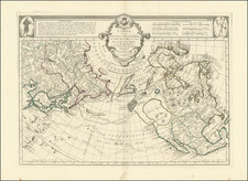
If a North West Passage Exists It Must Be Thru One of these Bays
Decorative map of North America, illustrating the extent of European knowledge of the interior parts of North America on the eve of its last major period of exploration.
The map reflects the state of affairs shortly after the conclusion of the American Revolution. This was a time when the United States was still consolidating its new found Independence, Spain, France and England were agitating settlers and Native populations on either side of the Mississippi River to consider breakaway republics, vast amounts of European and American capital were being spent investing in opening up the Ohio Valley and Russia was colonizing Alaska. Over the next several decades, exploration would radically change the known west, the Louisiana Purchase and Mexican Revolution would push out the last non-British colonial powers from the continent, and ambitious explorations would re-write the known geography of the Transmississippi West and Arctic regions of North America.
The map shows the British Colonies still extending to the Mississippi, although Pennsylvania is now truncated. East and West Florida are shown. The northwest coast of America is still New Albion, with the Straits of Martin Aguilar shown, as is the Straits of Juan De Fuca. Pre-dates MacKenzie's explorations in northwest Canada.
The port where Sir Francis Drake remained for 5 weeks (Drake's Bay, north of San Francisco) is shown.
![Carte Generale Des Etats Unis De L'Amerique Septentrionale Renfermant Aussi Quelques Provinces Angloise . . . [Shows State of Franklin!]](https://storage.googleapis.com/raremaps/img/small/98580.jpg)