


|
||

|

|
|

|
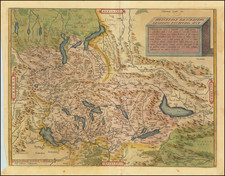
Nice color example of Ortelius' map of Switzerland, from his Theatrum Orbis Terrarum, the first modern atlas of the world.
The map shows the region orientated with south at the top of the map, effectuating a reversal of normal cartography. Lake Geneva, "Lemanus Lacus" is to the right of the map, and Geneva is shown near there. The many other Alpine lakes are shown and name,d as are rivers. The Rhine enters Switzerland near the center of the map before reaching its headwaters above the Acronius Lacus (Obersee). Detail extends southwards (to the top of the map) into Lombardy and southern France.
The map is based on the second edition of the Aegidius Tschudi map of the region, published by Konrad Wolfhart in 1560. Ortelius also mentions as his additional sources general maps of Switzerland by Adelbergus Sauracher and Johann Stumpf, as well as regional map of Wallis by Joannes Schalbeter and Zurich by Josias Murer.
States
This is the second state of the map, with the additional place names around Lake Geneva, which first appeared in 1584.
Ortelius's Theatrum Orbis Terrarum (or "Theater of the World") is widely considered to be the first modern atlas, meaning that this was the first published set of uniform maps with supporting text gathered in book form. Previous bound map collections exist, for example the Italian Lafreri atlases, but these were sets of maps selected and bound together on demand. The Theatrum, in contrast, was the best available summary of sixteenth-century cartographic knowledge, covering much of the exploration of the world in the century following the discovery of America.
The atlas was first published in 1570 in Antwerp. Ortelius’ atlas outperformed later competing atlases from other cartographic luminaries like the De Jode and the Mercator families. The broad appeal of the work is demonstrated by the array of languages in which the atlas appeared: in addition to Latin, the atlas was published with text in Dutch, French, German, Italian, Spanish, and English. Between 1570 and 1612, at least 31 editions of the atlas were published in seven languages. The editions grew over time, with the first edition having 70 maps on 53 sheets, and the 1612 edition having 167.
At the time of its publication, the Theatrum was the most expensive book ever produced. Ortelius created all the maps personally, hand drawing the rough sketches. Those drawings were then interpreted into prints by his engravers Frans Hogenberg, Ambrosius Arsenius, and Ferdinand Arsenius.
After Ortelius's death in 1598, the copper plates for his atlas passed to his heirs. They, in turn, sold the collection to Jan Baptist Vrients (1522-1612) in 1601. Vrients added new maps and published the atlas until his own death in 1612. Vrients's widow then sold the plates to the Moretus brothers, who were the successors of Christoffel Plantin. Recent research has unearthed examples of the atlas with maps dated to 1640.
Abraham Ortelius is perhaps the best known and most frequently collected of all sixteenth-century mapmakers. Ortelius started his career as a map colorist. In 1547 he entered the Antwerp guild of St Luke as afsetter van Karten. His early career was as a business man, and most of his journeys before 1560, were for commercial purposes. In 1560, while traveling with Gerard Mercator to Trier, Lorraine, and Poitiers, he seems to have been attracted, largely by Mercator’s influence, towards a career as a scientific geographer. From that point forward, he devoted himself to the compilation of his Theatrum Orbis Terrarum (Theatre of the World), which would become the first modern atlas.
In 1564 he completed his “mappemonde", an eight-sheet map of the world. The only extant copy of this great map is in the library of the University of Basel. Ortelius also published a map of Egypt in 1565, a plan of Brittenburg Castle on the coast of the Netherlands, and a map of Asia, prior to 1570.
On May 20, 1570, Ortelius’ Theatrum Orbis Terrarum first appeared in an edition of 70 maps. By the time of his death in 1598, a total of 25 editions were published including editions in Latin, Italian, German, French, and Dutch. Later editions would also be issued in Spanish and English by Ortelius’ successors, Vrients and Plantin, the former adding a number of maps to the atlas, the final edition of which was issued in 1612. Most of the maps in Ortelius' Theatrum were drawn from the works of a number of other mapmakers from around the world; a list of 87 authors is given by Ortelius himself
In 1573, Ortelius published seventeen supplementary maps under the title of Additamentum Theatri Orbis Terrarum. In 1575 he was appointed geographer to the king of Spain, Philip II, on the recommendation of Arias Montanus, who vouched for his orthodoxy (his family, as early as 1535, had fallen under suspicion of Protestantism). In 1578 he laid the basis of a critical treatment of ancient geography with his Synonymia geographica (issued by the Plantin press at Antwerp and republished as Thesaurus geographicus in 1596). In 1584 he issued his Nomenclator Ptolemaicus, a Parergon (a series of maps illustrating ancient history, sacred and secular). Late in life, he also aided Welser in his edition of the Peutinger Table (1598).
![[Valais Canton] Das under Wallisserlandt](https://storage.googleapis.com/raremaps/img/small/95848.jpg)
![Atlas Novus Reipublicae Helveticae XX. Mappis . . . [with] Schweitzer-Geographie. Samt den Merkwurdigkeiten in den Alpen und hohen Bergen. Zur Erläuterung der hommannischen Charten herausgegeben](https://storage.googleapis.com/raremaps/img/small/84155.jpg)
![[Course of the Rhine River] Corso del Reno Parte Septentrio [and] Corso del Reno Parte Meridionale . . . 1690](https://storage.googleapis.com/raremaps/img/small/73095.jpg)