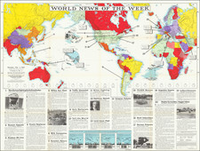


|
||

|

|
|

|
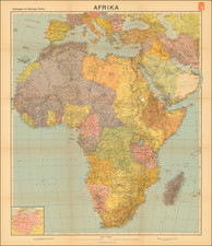
"Afrika", published by Velhagen & Klafing in Bielefeld and Leipzig in 1940, is an intriguing example of mid-20th-century European cartography, capturing the geopolitical landscape of Africa from a distinctly German perspective during a tumultuous time in world history. The map notably includes an inset comparison of the size of the German Reich, subtly revealing the cartographic projection of nationalistic sentiments and territorial ambitions of Nazi Germany.
The map's publication during the Nazi era and the height of World War II presents a significant historical context. While the primary focus of the map is the African continent, the inclusion of "Deutsches Reich zum Vergleich" (German Reich for comparison) reflects Germany's geopolitical aspirations and the regime's vision of territorial expansion. The map thus serves not just as a geographical tool, but also as a mirror to the ambitions of the Nazi era, when cartography was often used as a means of disseminating political ideology and reinforcing territorial claims.
From a broader perspective, this map can be interpreted as a reflection of the last vestiges of European colonialism in Africa. The depiction of Africa in the map, in conjunction with the reference to the German Reich, subtly echoes the long history of European powers staking their claims over African territories. This is particularly resonant considering the Berlin Conference of 1884-85, where European powers had partitioned Africa among themselves, and the subsequent decolonization processes of the mid-20th century.
In terms of its design and information presentation, the map includes a detailed key explaining various symbols and labels used for depicting geographical features, settlements, transportation routes, and more. The key reveals the map's intention to present a comprehensive picture of Africa's physical geography and human settlement patterns, but within the parameters and perspectives set by its German publishers.
![(Second World War - Italian Propaganda Poster) i 50 Sbarchi in Gran Bretagna
[The 50 Landings in Great Britain]](https://storage.googleapis.com/raremaps/img/small/86443.jpg)
![[Africa] Prima Tavola](https://storage.googleapis.com/raremaps/img/small/96586.jpg)
![[Untitled Map of The Atlantic Ocean, Europe, Africa, the Middle East, and Eastern Canada]](https://storage.googleapis.com/raremaps/img/small/89582.jpg)