|
||

|

|
|

|
Stock# 87556
Description
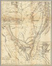
Interesting hand-drawn manuscript map of the Holy Land featuring a simplified configuration of the territories of the Twelve Tribes of Israel.
The map shows a simplified plan for Jerusalem divided among: The Holy Portion for the Sanctuary and the Priests; The Portion for the Levites; The portion for the City; and A Portion for the Prince.
An inset in the upper-left corner shows the Eastern Hemisphere (Old World) with a strange rendering of Australia (labeled "New Holland"), that map titled: "A map of Europe, Asia, and Africa to shew the central situation of the city of Jerusalem."
Condition Description
Pen and watercolor manuscript on paper.
![[The Gospel of John - Eagle]](https://storage.googleapis.com/raremaps/img/small/49807.jpg)
![[Solomon's Kingdom] Regnum Salomonicum Seu Tabula digesta ad Libros Iudicum Regum, Paral. et Prophet Per Eparchias XII, Mox Regna duo Auctore Phil. de la Rue . . .](https://storage.googleapis.com/raremaps/img/small/92371.jpg)