The item illustrated and described below is sold, but we
have another example in stock. To view the example which
is currently being offered for sale, click the
"View Details" button below.


|
||

|

|
|

|
Stock# 87357
Description
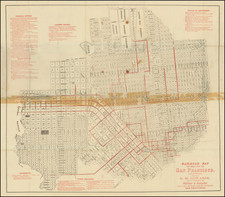
Scarce folding map of San Francisco, with west at the top, printed in black and red, focusing on the city's budding urban rail system.
Rumsey (258) dates his example to 1874 based on the "new mint" at 5th and Mission. The first successful San Francisco cable car line began operation in 1873, so most of these routes are traditionally powered with horses or other means of propulsion.
The map's author has included lists of federal offices, state offices, leading hotels, public buildings, and places of amusement in red at the sides of the map.
Condition Description
Folding map printed in black and red. Minor wear and toning at folds. Original paper folder with ink stamp of "C. Beach, Books & Stationery, 5 Montg'y St., S.F." on the interior of the front cover.