


|
||

|

|
|

|
Charting the Caribbean While in Exile
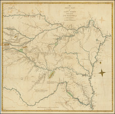
Largely unknown yet fascinating map of Florida, the Gulf of Mexico and the Caribbean, by one of Spain’s foremost hydrographers, Felipe Bauza.
Bauza produced this chart while in exile in London. Although he still worked on behalf of his native country, while in London he also produced original charts for sale. This chart, though in Spanish, was likely printed and sold in London to navigators eager for the most up-to-date information on the lucrative trade region.
A later chart (1836) closely based on this one is known in several examples, but this rare chart is known in only one example, at the British Library. Its publication history, and intertwined history with the political machinations of Spain in the early-nineteenth century, has not been explicated before.
This new chart is based on one that Bauza prepared in 1799 for the Dirección de Hidrografía. Much has changed in the intervening years. This chart shows more of the Caribbean to the east, including more of Cuba, the Bahamas, and Jamaica. The information is presented more crisply and concisely, and several areas have been reshaped based on newer information, like the Mississippi Delta, the coasts of Cuba, Lake Tamiagua in Veracruz, and St. Ana Lagoon in Tabasco. The present chart also has considerably more navigational detail, especially in the Grand Bank of the Bahamas and near the Yucatan Peninsula.
There is a list of lighthouses on the Florida coast in the lower left corner, necessary because of the many reefs in that area. While the coast is more precisely wrought than on the previous 1799 chart, a large portion of the Florida shore is still undelineated, having not been adequately explored by the Spanish prior to the Adams Onis Treaty. Therafter Mexico's independence from Spain limited the Spanish presence in the Spanish Main.
In inland Texas is a key with letters indicating the quality of the bottom throughout the chart. Nearby is a profile view.
Bauza’s erudition is on full display in the text and table in the upper right. He lays out the astronomically-derived coordinates he used to anchor the chart. He also gives a long list of the navigators whose measurements he used, including such luminaries as Alexander Humboldt.
Another of these was José Joaquín de Ferrer, whose track from New Orleans to Santander is included on the chart. Ferrer was a Basque astronomer. A member of the American Philosophical Society, he was known around the Atlantic world for his work on eclipses. He is credited with the first use of the word “corona” for the crown of light seen during a total eclipse. He also worked as a surveyor in the Gulf of Mexico; for example, he calculated the location of the mouth of the Red River, coordinates that were brought up as part of the negotiations for the Louisiana Purchase.
Bauza in exile
Bauza was a Spanish naval officer and skilled hydrographer, originally from Majorca. Head of the Depósito Hidrográfico, he entered into politics in 1822 following the 1820 coup that led to a liberal constitutional government. This was a troubled time in Spanish politics, and the suspicions of Ferdinand VII, reinstated in 1823 by a French army, soon fell on Bauza and his associates. In that year, Bauza and hundreds of others were condemned; their families were forced to flee.
Bauza’s considerable contacts in the wider European scientific community proved to be his salvation. Henry Richard Vassall Fox, third Baron Holland, helped Bauza and other Spanish refugees to flee to Gibraltar. Bauza’s wife and three children stayed there, but Bauza, and a huge collection of charts and documents, journeyed on to London.
Installed in a house in Johnson Street in Somers Town, Bauza entered into London’s intellectual society. He quickly became the authority on South American mapping and was sought out by the Admiralty for his expertise. Captain W. E. Parry, Royal Hydrographer, sponsored his membership in the Royal Society. Later, Francis Beaufort, Parry’s successor, introduced Bauza to the Royal Geographical Society. He corresponded with Philip Parker King, F. W. Beechey, John Franklin, and other prominent navigators. He also visited William Herschel’s observatory at Slough and went to visit Alexander Humboldt in Paris.
Although in exile, he still worked on behalf of his native country. He facilitated the ordering of instruments for Spanish observatories, requested information about the installation of lighthouses in Spanish ports from Trinity House, and corresponded about charting with hydrographers still resident in Spain. However, the death sentence hanging over him was confirmed in 1826, meaning he could not return.
His exile was finally lifted in 1832, part of a larger amnesty issued by Queen Maria Christina. However, Bauza’s health did not allow him to take up this opportunity. He died in March 1834 and is buried in Moorfields, London. The huge chart collection he amassed made its way into the British Library and other repositories.
States of the chart and the politics of mapping
This chart was made during Bauza’s busy time in London, when he was still trying to contribute to the hydrographic knowledge of Spain, as well as his adopted home. The chart, though in Spanish, touts his fellowship in the Royal Society and the contributions of both Spanish and British naval officials to its construction. It was most likely printed in London.
Interestingly, the chart seems to be part of a larger political campaign. A later version of the chart appears with a Madrid imprint, the correction of the Florida coast, and the removal of the original title and the text in the upper right corner, printed in 1836. The dedication in that chart’s title cartouche says it was presented to Queen Maria Christina by Juan Álvarez Mendizábal, then Spanish Prime Minister and former political exile in London, where he knew Bauza.
It seems likely that the present chart, published in 1828, was Bauza’s initial compilation effort to correct his 1799 chart. The chart mentioned as compiled by Bauza in 1829 in the title of the 1836 Madrid chart, of which no examples are known, is likely a new plate closely related to this one, with a London imprint included below the neatline. Indeed, if you look below the neatline of the 1836 state, you can see an erased imprint, likely one that stated that the chart was printed in London.
Álvarez Mendizábal returned to Spain around the time of Bauza’s death. It is possible that he carried the 1829 chart with him, which was then repurposed by the Dirección de Hidrografía for the 1836 state.
Rarity
This earlier chart shows the skill and mastery of an important hydrographer during his political exile. It is practically unrecorded and very rare. We locate only one other example, in the British Library.
There are no known examples of an 1829 chart and it is possible this edition was never printed. The 1836 chart survives in at least four examples at the Royal Library of Belgium, the University of Texas, Arlington, the Museu Marítim de Barcelona, and the Institut Cartografic I Geologic de Catalunya.
Felipe Bauza (1764-1834) was a Spanish naval hydrographer who served in important roles on the Malaspina expedition and in the Spanish hydrographic administration. Born in Palma, Majorca, Bauza joined the Spanish navy at fifteen. A promising young officer, Tofiño y Varela employed him on surveying for the maritime atlas of Spain.
This work got him appointed as a hydrographer on the Malaspina expedition, Spain’s answer to the voyages of James Cook and La Perouse. Bauza was in charge of charting on the expedition. On the way back to Spain, he and a colleague, Espinosa y Tello, traveled overland from Valparaíso to Buenos Aires, making important observations along the way. However, back in Spain, the publication of the materials from the expedition staled due to political machinations.
Bauza was appointed to the Dirección de Hidrografía in 1797, where he served for decades. After fighting for Spanish independence from Napoleon’s troops, Bauza returned to Madrid to take on the Depósito Hidrográfico. This was not his only accolade; Bauza was a member of the Real Sociedad Económica Matritense (1805), the Real Academia de la Historia (1807), the Royal Bavarian Academy (1816), the Royal Society of London (1819), the Turin Academy of Sciences (1821), the Academia Nacional (1821), the Royal Geographical Society (1831), the Royal Maritime Society of Lisbon (1832), and awarded the Order of St. Vladimir by the Tsar of Russia.
In the 1820s, Bauza entered politics. This led to his exile in 1823. He lived in London, with a sizeable collection of charts that he had brought with him, hoping to return to Spain. However, in 1826, the Spanish Crown confirmed his death sentence. This sentence was finally lifted due to the amnesty of 1832 issued by Queen Maria Christina, but Bauza was not able to take it up. He died in London in 1834. His considerable chart collection was sold to various entities, including the British Admiralty, the British Museum, and the government of Venezuela.
![[ The Silver Route -- Mexico City to Santa Fe, New Mexico ] Carte de la Route qui mene depuis la Capitale de la Nouvelle Espagne jusqu'a S. Fe. du Nouveau Mexique Dressee sur les Journaux de Don Pedro de Rivera et en partie sur les Observations Astronomique de Mr. de Humboldt.](https://storage.googleapis.com/raremaps/img/small/102164.jpg)

![[Texas Centennial Exposition]](https://storage.googleapis.com/raremaps/img/small/76381.jpg)
![[Mexico City and Environs] Mapa de las Lagunas, Rios y Lugares que Circundan a Mexico: para mayor inteligencia de la Historia y Conquista de Mexico que escribió Solis . . . 1783](https://storage.googleapis.com/raremaps/img/small/91029.jpg)