This item has been sold, but you can enter your email address to be notified if another example becomes available.


|
||

|

|
|

|
Stock# 86666
Description
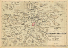
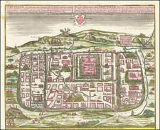
Rare Dutch Edition of one of the First Scientific Maps of Jerusalem
Finely executed map of the area around Jerusalem, published in Amsterdam.
Wessing's map is based upon on Richard Pococke's A plan of Jerusalem and the Adjacent Country, engraved by Thomas Jefferys. Wessing alters the map, with a greater focus on the city, and less the environs of Jerusalem.
The map shows both the ancient and modern city within walls. The roads to Jaffa, Bethlehem and Jerico are depicted.
Richard Pococke visited the Middle East in 1737-38. He published an account of his travels, "A Description of the East," in 1743-45. His map was one of the first scientific maps of Jerusalem based on first hand observation.
![[ Jerusalem ] Ierusalem](https://storage.googleapis.com/raremaps/img/small/88440.jpg)