|
||

|

|
|

|
The First U.S. Claim to Texas.
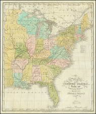
A handsome example of the second edition, third issue, of Abraham Bradley's postal map of the United States, one of the most important early maps of the United States, and a landmark in both American postal history and cartography.
This is the very desirable and unusual circa 1809 issue of the map, which is the first map to advance a U.S. claim to Texas (i.e., the lands northeast of the Rio Grande or "North R.", as it is called here). The map was made during a brief window in time following the Louisiana Purchase but before the War of 1812, when expansionist optimism reached a temporary apex among U.S. policymakers. In previous versions of his map, Bradley had a history of including early American claims to lands that would eventually be annexed by the United States (namely in West Florida, which he showed as part of the United States at the behest of Thomas Jefferson.) Bradley's decision to do so with Texas on this map created a record of the U.S. intention to annex Texas almost forty years before that vision became a reality.
Background and Bradley's Postal Maps
In addition to being one of the earliest wall maps of the United States published in the United States, Bradley's map “represented the first clear cartographic break from European-dominated mapmaking and introduced a new, more distinctly American style of cartography to the United States” (Ristow). For 30 years, Bradley's was the map-of-record for the postal system of the United States, far and away the government's largest and most impactful branch. The map delineates the postal routes throughout the United States and gives the distances and times between stops. The map was continuously updated by Bradley and thus preserves fine detail about the rapidly changing American landscape of the early 19th century. Bradley’s map was also kept current regarding political geography and was continuously updated to show newly created states, territories, and counties.
Abraham Bradley was a Litchfield, Connecticut-born lawyer who had an extraordinary career as a senior civil servant in the U.S. Post Office Department. He joined the Postal Department in 1792, was promoted to First Assistant Postmaster General in 1800, and served until being removed from office in the Jacksonian purges of 1829. When the first edition of his postal map was published in 1796, it was one of only four large format maps of the United States to have been produced in America before 1800.
It is hard to overstate the importance of the Postal Department in the first decades following the Revolution. The Founders saw effective postal service as a precondition for an informed citizenry and vibrant democracy, and Postmaster General was one of the first Cabinet positions created by Washington. At times during Bradley's tenure, The Postal Department accounted for more than 75% of the federal bureaucracy. By his retirement, Bradley oversaw more than 8000 local offices and 110,000 miles of post roads. During these years, Bradley essentially acted as the Department's Chief Operating Officer, overseeing, among other things, route selection, contracting, finances, and even responding to complaints about lost or stolen mail. In light of his position, Bradley was arguably the American most motivated to produce a viable postal map and certainly the best informed.
Like many American officials in the first half-century of the nation's existence, Bradley was allowed to leverage the official information to which he had access into his private postal map venture. The map existed in a quasi-official grey zone for decades (receiving input and direction from government officials, but not being an actual publication of the federal government), until 1825, when it was adopted as the official map of the U.S. Postal Service.
Bradley's maps were extremely useful for navigating the emergent thoroughfares of the new nation. During his travels in America, Louis Philippe, Duc d'Orléans, future King of France (1830-1848), used Bradley's map to plan and execute his famous tour of the States. Louis Philippe spent more than three years in American exile, from 1796 to 1800. At the beginning of his exile in 1796, he and his two brothers visited an aging George Washington at Mount Vernon, where they revealed their desire to explore the mysterious interior of America. Washington presented them with a copy of the first state of Bradley's map and outlined a route for the brothers in red. The map became a favorite keepsake for Louis Philippe, who years later, as King of France, would proudly produce the map for visitors and share the story of how Washington had annotated it in his own hand.
The definitive study of Bradley's postal maps was produced by Michael Buehler and Larry Caldwell in the Spring 2010 issue of the Portolan, titled "Picturing a Networked Nation: Abraham Bradley's Landmark U.S. Postal Maps".
Dating the Map
There is a temptation to date the present map to 1810 or 1811, as it shows West Florida subsumed into Orleans Territory, a change that formally occurred in late 1810 after the formation and near-immediate U.S. annexation of the Republic of West Florida. This dating matches much of the other internal evidence. For instance, Illinois Territory (formed in 1809) is shown, but the State of Louisiana (formed in 1812) is not. Despite this seemingly obvious bit of evidence, the Orleans Territory configuration is a red herring. Bradley's maps had a history of advancing expansionist claims to West Florida that date back at least to 1804. A near contemporary account (in the 1814 Salem Gazette) relates how Thomas Jefferson used Bradley's map to advance American claims to West Florida:
...when Jefferson purchased Louisiana, he happened at his leisure to conceive the plan of including West Florida in the purchase, and, to give colour of title, he directed Abraham Bradley, when he published his coloured map of the United States, to draw the same paint brush over Louisiana and West Florida; they are accordingly both painted with the same green color, and thus our title to that disputed territory is forever put at rest by a half-penny worth of paint in water colours.
This is confirmed by an examination of the preceding 1806 state, which also shows Orleans Territory extending over West Florida, but, for instance, not Illinois Territory, which was created before General Claiborne actually took power in Baton Rouge.
The 1809 Issue: The First American Claim on Texas
The present 1809 map was conceived at a time of budding expansionist sentiment in the United States. The Louisiana Purchase had recently been concluded under surprisingly favorable conditions, and with the European powers still distracted and impoverished by the Napoleonic Wars, it was an opportune time to consider consolidating the poorly-defended territories on the rapidly-expanding borders of the United States.
West Florida (as well as Florida generally) was an obvious target, and as mentioned above, Bradley began sewing the seeds of that claim years before West Florida's acquisition came to fruition.
Another potential target was Texas, which at the time was a barely inhabited borderland between the Sabine and Rio Grande. We know from contemporary accounts that Texas ("the Country between the Sabine & Bravo") was a target for invasion in 1811, as the U.S. considered how to best secure its interests in the event of a war with Britain and potentially Spain.
So, just as Bradley had done to West Florida years earlier, in this 1809 state of the map, he expanded the southwestern border of the United States. The border transformed from the faintly-drawn line arcing northwest from the San Jacinto River in the 1805 issue into a well-articulated dotted line following the eastern edges of the Rio Grande and Pecos River up onto the Great Plains. Furthermore, Bradley added a northern border to the territory, extending it west from the present-day northern boundary of the State of Louisiana. This very intentional change created a new U.S. "territory," probably best termed an extension of Orleans Territory, very closely prefiguring the borders of present-day Texas.
If the West Florida change can be considered any kind of precedent, Bradley's extension of the United States to the Rio Grande probably came at the direction of the highest levels of the U.S. government.
The configuration continued in the 1812 issue of the map, though this time, the territory was completely separated from the newly-formed State of Louisiana, and the name "Orleans Territory" was completely obliterated, leaving the area nameless.
When the third edition was issued in 1825, the U.S. claim on Texas was given up, and the land clearly indicated as part of Mexico.
Editions and States
As alluded to above, there are three editions of the Bradley Postal map. The first, issued in 1796, was a four-sheet map (35.5 x 31 inches). The second edition, first issued in 1804, is nearly twice the size, with significantly more coverage west of the Mississippi River. The third edition was issued in 1825.
When Bradley first published his first map, most citizens of the fledgling United States still had no real conception of the magnitude of their young nation. The postal map was on public display in almost every large post office in the country, and it provided citizens with an impressive visual depiction of the scope of the United States at a time when the search for a national culture and national identity was still underway. As noted by Buehler and Caldwell say of the first edition:
What makes the map extraordinary is its depiction of the American postal system in a single coherent image. It shows every one of the roughly 450 existing post offices and every postal route, with distinctive symbols differentiating "post roads," "post roads established by contract," and "post and stage roads." Each route is marked to indicate the mileage between post offices. The varying density of the network displayed on the map serves as a profile of national expansion and development. ("Mapping a Networked Nation," p. 10)
The 1796 edition quickly became outdated with the rapid expansion of the United States. Between 1796 and 1804, the postal service more than tripled in size from 450 to 1405 post offices. With the Louisiana Purchase of 1803, the need for this second edition became imperative. Most evident is the expansion of the coverage of the map much farther west than the 1796 edition, with the size of the map nearly doubling and the coverage extending west to include the newly created Orleans Territory (existing from 1804 to 1812) as well as showing the lower part of the Missouri River and other western tributaries of the Mississippi River, areas recently acquired from the French. In place of the timetable on the 1796 map, a large inset map of North America was added, which clearly displays the extent of the Louisiana Purchase and names it as such. It also shows the boundaries of the newly formed territories of the youthful country.
Perhaps of greatest note in the inset, there is a delineation of Orleans Territory extending to the Rio Grande and a larger depiction of Louisiana Territory as including all of Texas.
Rarity
Caldwell & Buehler record the following examples of the circa 1809 issue: Library Company of Philadelphia, MacLean Collection, Free Library, Rumsey Collection, University of Virginia, Yale-Sterling, and an example in a private collection.
Abraham Bradley was born in Litchfield, Connecticut. He is an important figure not only in early American cartography, but in early American history as well. Initially, Bradley trained as a lawyer and moved to the Wyoming Valley of Pennsylvania to practice. There he met Judge Thomas Pickering, who took Bradley with him to Philadelphia when he was appointed Postmaster General by George Washington in 1791.
As Pickering's clerk, Bradley created postal maps which showed the budding system of post offices and routes. A self-taught mapmaker, Bradley quickly gained considerable skill and became well-known for this carefully drawn maps. His most famous map is the postal route map of 1796, which shows the young United States and includes an innovative table that calculated the time it would take a letter to travel around the country.
In 1799, Bradley was appointed Assistant Postmaster General, a position he would hold until 1829. As part of his duties, Bradley supervised the moving of the General Post Office Department from Philadelphia to Washington DC. In 1804, with the help of British mapmaker Aaron Arrowsmith, Bradley updated his postal map, which featured in practically every post office in the states and territories. Bradley would continue to create route maps, and to update his most famous map, throughout his career, including in 1810 and 1825.
During the burning of Washington DC in the War of 1812, Bradley housed the records and archives of the General Post Office Department in his Maryland farmhouse. His service with the Post Office came to an abrupt end, however, with the election of Andrew Jackson. Although he had served under five Postmasters General, Jackson dismissed Bradley for partisan reasons. Bradley then served as secretary to the Franklin Insurance Company. He died at his farmhouse in 1838, leaving behind eight children. He is remembered for his careful custodianship of the nascent Post Office, and for creating maps that made Americans feel connected to their fellow citizens.
![[ First Gold Rush Edition! ] Colton's Map of the United States of America, The British Provinces, Mexico, The West Indies and Central America . . . 1849](https://storage.googleapis.com/raremaps/img/small/101951.jpg)