|
||

|

|
|

|
Stock# 86057
Description
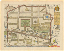
Nice and scarce large plan of Jerusalem, showing the Holy City in block-by-block detail. With vibrant red colors and topographical shading, this "croquis" (sketch) is a true representation of the city just after the turn of the century.
The map names hundreds of features throughout the city, including the holy sites (Jewish, Christian, and Muslim), and indications of the various ethnic groups that lived in the region. Roads, waterways, peaks, and other features are shown.
This map was published by Hugues Vicent to accompany his important early survey of Jerusalem that covered important archeological findings. The map was published in 1912 in Paris.
Condition Description
Repaired tear in left of map, with associated tape stain.