


|
||

|

|
|

|
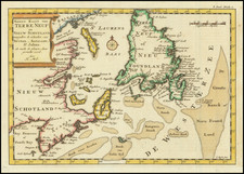
Rare and attractive James Wyld map of Upper Canada, showing the course of the St. Lawrence River with detail extending into New England, New York, and the Great Lakes Region.
The map is brightly designed and attractively colored, showing the region in fine detail. The county structure of each region is shown, with some counties north of the St. Lawrence extending far into the northern wilderness. Information on the inland hydrography of Quebec and Toronto ranges from accurate to conjectural. Parts of Nova Scotia, Maine, New Hampshire, Vermont, New York, and Massachusetts are also visible.
This appears to be a later state of a map of the same title which, in 1851, included an inset in the upper left, a slight extension of the map into New York, and numerous other large changes. The map includes the rail line going through Guelph, which didn't happen until 1856.
James Wyld Sr. (1790-1836) was a British cartographer and one of Europe’s leading mapmakers. He made many contributions to cartography, including the introduction of lithography into map printing in 1812.
William Faden, another celebrated cartographer, passed down his mapmaking business to Wyld in 1823. The quality and quantity of Faden’s maps, combined with Wyld’s considerable skill, brought Wyld great prestige.
Wyld was named geographer to Kings George IV and William IV, as well as HRH the Duke of York. In 1825, he was elected an Associate of the Institution of Civil Engineers. He was one of the founding members of the Royal Geographical Society in 1830. Also in 1830, his son, James Wyld Jr., took over his publishing house. Wyld Sr. died of overwork on October 14, 1836.
James Wyld Jr. (1812-87) was a renowned cartographer in his own right and he successfully carried on his father’s business. He gained the title of Geographer to the Queen and H.R.H. Prince Albert. Punch (1850) described him in humorous cartographic terms, “If Mr. Wyld’s brain should be ever discovered (we will be bound he has a Map of it inside his hat), we should like to have a peep at it, for we have a suspicion that the two hemispheres must be printed, varnished, and glazed, exactly like a pair of globes.”

![[Nova Scotia Railway -- Shubenacadie Canal] (Hand Drawn Survey Maps)](https://storage.googleapis.com/raremaps/img/small/92802.jpg)