|
||

|

|
|

|
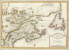
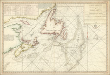
Theis 1758 antique map, titled A Map of the Harbour of Louisbourg and parts adjacent, depicts the harbor of Louisburg, Cape Breton, Canada, during the time of its second British capture. Published in the London Magazine, this map provides valuable insights into the strategic significance of Louisbourg, a key French settlement fortified with an imposing fortress.
Louisbourg played a critical role in the conflicts of the 18th century. Initially captured by British colonists in 1745, the settlement became a significant bargaining chip in the negotiations that led to the 1748 Treaty of Aix-la-Chapelle, which ended the War of the Austrian Succession. As part of the treaty, Louisbourg was returned to the French in exchange for border towns in present-day Belgium.
However, the strategic importance of Louisbourg continued to draw attention, and the settlement was captured once more by British forces in 1758 during the Seven Years' War. Following this second capture, British engineers systematically destroyed the fortress's fortifications to prevent its future use as a military stronghold.
Thomas Kitchin was a British cartographer and engraver. Born in Southwark, England, Kitchin was the eldest of several children. He was apprenticed to the map engraver Emanuel Bowen from 1732 to 1739, and he married Bowen’s daughter, Sarah, in December 1739. By 1741 Kitchin was working independently and in 1746 he began taking on apprentices at his firm. His son Thomas Bowen Kitchin was apprenticed to him starting in 1754. By 1755 Kitchin was established in Holborn Hill, where his firm produced all kinds of engraved materials, including portraits and caricatures. He married his second wife, Jane, in 1762. Beginning in 1773 Kitchin was referred to as Hydrographer to the King, a position his son also later held. He retired to St. Albans and continued making maps until the end of his life.
A prolific engraver known for his technical facility, clean lettering, and impressive etched decorations, Kitchin produced several important works throughout his career. He produced John Elphinstone’s map of Scotland in 1746, and the first pocket atlas of Scotland, Geographia Scotiae, in 1748/1749. He co-published The Small English Atlas in 1749 with another of Bowen’s apprentices, Thomas Jefferys. He produced The Large English Atlas serially with Emanuel Bowen from 1749 to 1760. The latter was the most important county atlas since the Elizabethan era, and the first real attempt to cover the whole country at a large scale. In 1755 Kitchin engraved the important John Mitchell map of North America, which was used at the peace treaties of Paris and Versailles. In 1770 he produced the twelve-sheet road map England and Wales and in 1769–70 he produced Bernhard Ratzer’s plans of New York. In 1783, he published The Traveller’s Guide through England and Wales.
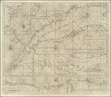
![[ Charleston, Boston, New York, St. Augustine, Bahamas, etc ] Particular Draughts of some of the Principal Towns and Harbours belonging to the English French and Spanish in America and the West Indies.](https://storage.googleapis.com/raremaps/img/small/102804.jpg)