|
||

|

|
|

|
Stock# 85318
Description
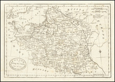
Rare mid-19th Century map of "Ancient Poland", showing its "actual delimitations."
Issued several times over a course of years, the boundary coloration on this map seems to be quite unusual. We note examples in several European Libraries with different dates (1863) and different color schemes, but this present color scheme seems only to match the 1861 example at the University of Wroclaw, which is also an 1861 edition.
Condition Description
Segmented and laid on linen, as issued.
![Moscovia Parte Orientale . . . [with] Parte Occidentale . . .](https://storage.googleapis.com/raremaps/img/small/26615.jpg)
![[Wroclaw] Carte du Diocese de Breslau, avec ses IV. Archidiaconats, subdivses en ses Cercles Archiprebyteriales desineee sous la Directiondu bien reverend Sieur Felbiger . . . MDCCLI](https://storage.googleapis.com/raremaps/img/small/59627.jpg)