


|
||

|

|
|

|
Stock# 84978
Description
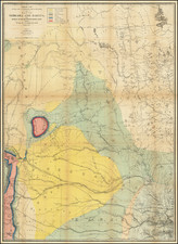
Topographical map of sparsely-populated south-central South Dakota by the U.S. Geological Survey in 1:250,000 scale. Much of the White River watershed is shown, as well as Rosebud and Pine Ridge Indian Reservations. Lacreek Migratory Waterfowl Refuge (now National Wildlife Refuge) is to the south of Pine Ridge Reservation and part of Badlands National Monument (now National Park) is to the reservation's northwest.
Condition Description
Some creases near edges. Right margin a bit crunched.
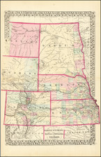
![Johnson's Nebraska, Dakota, Montana and Kansas [Rare Pre-Wyoming Territory configuration]](https://storage.googleapis.com/raremaps/img/small/94909.jpg)