|
||

|

|
|

|
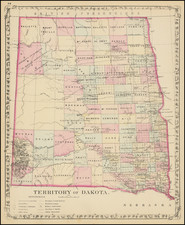
First Appearance of the Dakota Cession
Important early map of Minnesota Territory and the newly delineated Dakota Territory, from the 1859 edition of Mitchell's Universal Atlas, issued by Charles Desilver.
The map is based largely on the works of Nicollet and Pope, and includes extensive notes on early exploration and topography throughout.
The map notes at the bottom right:
LANDS OF THE DAKOTA OR SIOUX INDIANS
By the treaties of Traverse des Sioux, and Mendota concluded in the year 1851, the Dakota or Sioux Indians ceded all their lands to the United States lying in Minnesota, and Iowa between the Mississippi and Sioux rivers, and between Lat. 42° 37' N. and Lat.47°10' N. extending N. and S. 338 miles, and E. and W. from 100 to 250 miles. Area about 59,100 square miles. or 38 million acres, comprising a region fully equal in extent to the States of Pennsylvania and New Jersey.The Dakota Reserve, a tract of land on the head waters of the Minnesota river 120 miles in length, and 20 miles wide. has been appropriated by treaty for the use of said Indians.
The red line is the boundary of the Dakota cession.
An essential map for Minnesota and Dakota collectors.
Dakota's Path to Territorial Status
The period leading up to 1861 was a transformative period for what would become the Dakota Territory. As the mid-19th century approached, the region that now comprises North and South Dakota was mainly viewed as part of other territories. But shifts in borders, treaties, and statehood for some regions left a vacuum that settlers were keen to address.
From 1850, large portions of the Dakota region were initially recognized as parts of the Minnesota and Nebraska territories. This changed when Minnesota transitioned to statehood in 1858, leaving an expanse between its western boundary and the Missouri River unorganized and without clear governance or jurisdiction.
The same year, the U.S. Government signed the Yankton Treaty, which had profound implications for the region. Under this agreement, a significant amount of land, historically inhabited and recognized as Sioux territories, was ceded to the U.S. Following this cession, there was a notable push from settlers in the region to establish a more formalized governance structure. One key figure in these early organization efforts was Wilmot Wood Brookings, who temporarily acted as a provisional governor. The names of present-day locations like the cities of Wilmot and Brookings, as well as Brookings County, pay homage to his leadership.
However, the initial attempts by settlers to have the area recognized as an official U.S. territory were unsuccessful. This status quo was disrupted by the involvement of John Blair Smith Todd. As a relative of President-elect Abraham Lincoln, Todd utilized his connections and influence to passionately advocate for the region's territorial recognition. His lobbying proved effective when, in 1861, the U.S. Congress formally designated the area as the Dakota Territory.
With the official establishment of the Dakota Territory on March 2, 1861, its boundaries encapsulated a vast region. This territory extended far beyond current North and South Dakota borders, including areas now known as Montana, Wyoming, and a small portion of Nebraska. The first governor to oversee this new territory was William Jayne, appointed by President Lincoln.