This item has been sold, but you can enter your email address to be notified if another example becomes available.


|
||

|

|
|

|
Stock# 84691
Description
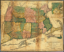
Striking birdseye view map of the Charles River, Massachusetts, published by George Walker in Boston.
The map extends from Waltham to Medway, showing the towns of Highlandville, Rockville, Medfield, Deham, Waban, Needham, Dover, South Natick, Wellsley, Newton and Riverside.
The view depicts numerous bridges, dams, roads and train lines.
Condition Description
An excellent, almost mint condition, example. Never folded. Probably part of a printer's or publisher's remainder.