|
||

|

|
|

|
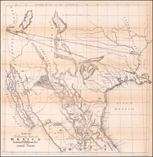
A Virtually Unknown Early Texana Map
Rare map of Mexico, including Texas, New Mexico and part of Upper California, published shortly after its independence.
This fascinating map appears to have a hidden past, which we have not entirely been able to follow. The foundational elements of the map would seem to be the 1824 Henry Tanner map of the Republic of the United States of Mexico and the 1822 Carey & Lea map of Mexico. There is a strong suggestion from its content that it relates to early printed pamphlets regarding Texas that were being published in very limited numbers in New York and elsewhere in the late 1820s, and in fact one of the two examples we located was dated 1829 (Texas State Archives copy). However, to date, we have not been able to determine with certainty its maker or dating.
The most salient feature of the map is a very clearly delineated boundary for Texas at a time when it was part of Mexico, with a distinct boundary line separating it from the neighboring provinces of Coahuila, Tamaulipas, and an area between New Mexico and Texas called "Interior of the East". It is possible that this border is intentional, but also possible that it is a mis-interpretation of the line on the 1825 Tanner, as the boundary does not appear on either the Carey & Lea (1822) or the White Gallaher & White Mapa de los Estados Unidos de Méjico . . . (1828).
The map would seem to largely defy attribution. Rumsey notes an example bound into an 1824 edition of the New General Atlas by John Thomson, published in Edinburgh, which includes a note that the map (with a companion map of South America) was bound in later. The only other example of the map which we could locate was in the Texas State Archives Collection, dated 1829 in the cataloging, but without attribution:
- Rumsey Copy: https://archive.org/details/dr_mexico-and-internal-provinces-published-by-john-thomson--co-edinburgh-2713066
- TSA Copy: https://www.tsl.texas.gov/apps/arc/maps/maplookup/00021
The map clearly shows numerous corrections and additions from an unknown earlier state, as erasures and corrections are evident in many places. Morever, it would seem that the map at some point extended further north and east. Longitude is shown from London at the bottom and Washington at the top, although not specifically identified. We surmise that an earlier edition of the map was likely a bit taller, covering the same area as the Carey & Lea Map of Mexico (1822-27).
While there are clear similarities between the Carey & Lea and the present map, the difference are noteworthy. These include:
- Clear Texas boundary in the present map
- Depiction of the Brazos (R. Brassos) River on the present map
- Depiction of Acalita de Bejar or St. Antonio on the present map
- Depiction of Galvorton and Bay of Galvarton on the present map
A later edition of the map, significantly revised, appears in the 1838 edition of Niles & Pease's History of South America and Mexico ...To Which is Annexed, A Geographical and Historical View of Texas, with a Detailed Account of the Texian Revolution and War. Various editions of this book were printed as early as 1824 or 1825, but there seems not to have been a map of Mexico incorporated into the map until the 1837 edition, when the map was titled Mexico & Texas. In this later state of the map, the title is moved and there are significant changes, most notably the addition of states in the United States and the removal of the vertical border separating Texas from the regions to west, which are not part of a much larger rendition of Texas.
The only map which we could locate which sounds similar to the present map is a printed map described in a 1963 catalog entry for Colonel Juan Dominguez's manuscript petition to establish the Dominguez Colony, March 18, 1828. Described in a 1963 Ebsertadt Catalog (Catalog 160, #554), the map is described as follows:
The map accompanying this remarkable manuscript is an American map of the period, measuring 15 by 14 1/2 inches, entitled “Mexico and Internal Provinces.” On it is marked in heavy green ink the extent of the grant---from 102° to 100° of longitude on the Arkansas River, south to about 32.5° of latitude and eastward (on the south bank of Red River) to 95° of longitude, comprising vast sections of the present States of Texas and Oklahoma, and placed squarely upon the then boundary of Mexico and the United States. The map gives both longitude “West from London” as here, and “West from Washington” as used in the petition.
The above description could be applied to the Carey & Lea map of Mexico in terms of its size, but also to the earlier edition of the present map. One would assume that Ebserstadt would have immediately recognized the Carey & Lea map, but of course that is supposition. The erasures on the present map include some erasures in the area where the Dominguez Grant would potentially have been shown, but this is far from conclusive. More curious are the curious misspellings of the Brazos (R. Brassos) and Alcalda de Bejar or San Antonio (Acalita) and Bay of Galvorton. These and several others suggest a reliance upon a earlier Spanish language map.
The name Rio Brassos appears as early as the March 26,1825 in correspondence by Henry Clay to Joel Roberts Poinsett on trying to locate a boundary line with the Mexican Commissioners during the efforts to establish a boundary with the Mexican commissioners:
. . . The line of the Sabine approaches our great western mart nearer than could be wished. Perhaps the Mexican government may not be unwilling to establish that of the Rio Brassos de Dios, or the Rio Colorado, or the Snow Mountains, or the Rio del Norte in lieu of it.
It is most frequently found in correspondence with Stephen F. Austin, where the name Brassos appears roughly 6 times, as early as October 11, 1829. For example, in the Austin Papers (p.458-59), a letter from William W. Morris to Austin dated New York, July 21, 1830 reads in part:
In the year 1829 towards the latter end I [Morris] wrote a pamphlet on the Subject of Texas, shewing the propriety and the necessity of annexing that Province to the United States, a copy of which I forwarded to you by Captain Thompson late of the Mexican Navy . . . Upon further investigation and enquiring into the plan of your settlement on the Rio Brassos . . .
![Amer. Sep. No. 70. Partie Du Mexique [Acapulco]](https://storage.googleapis.com/raremaps/img/small/96401.jpg)
![(Aztec Tribute List) [Original watercolor showing tribute items paid to the Aztecs by subject towns] Mendoza Col. part 1s Lorenzana, Aglio 1, Vol 22...](https://storage.googleapis.com/raremaps/img/small/102321.jpg)