


|
||

|

|
|

|
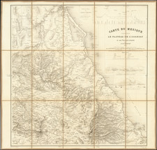
Striking Manuscript Map of the Mexican State of Querétaro
Colorful and detailed manuscript map of the state of Querétaro, in central Mexico. The map is drawn is a skilled hand and was likely prepared by an official for government use and possible publication.
The map shows the state divided into six districts, which are all labeled in bold. Roads are marked and they converge on cities and towns. Rivers and waterways are included as well. Bold lettering is also used to ring the state, explaining which states are neighbors to Querétaro: Michoacán, Guanajuato, San Luis Potosí, and México. Hidalgo, which also borders the state today, was not created as a state until 1869.
This helps to date this map to before the late-nineteenth century and the handwriting indeed indicates a date of ca. 1840. The author has also included a novelty compass rose, with a fletched arrow and tulip-tipped finials. A scale at the bottom is in leagues consisting of 5,000 Mexican yards each. The title is carefully drawn with decorative lettering that is shadowed using water colors. To the left is a legend explaining the following:
Explanation: The punctuated lines demarcate roads and the blue lines rivers and streams. Cities are indicated with a red circle. Villages with green. Those that are only a mission with purple. Minerals with blue. Labor and breeding haciendas with a °
The state of Querétaro
The Free and Sovereign State of Querétaro de Arteaga is one of the smallest of the 32 federal states of Mexico. Agricultural settlements date to 500 BCE and several indigenous groups lived in the area over the centuries, including the Otomi, Toltecs, Chichimecas, Purépechas, Mexicas, and, later, the Pames and the Chichmeca Jonaz. By the fifteenth century, both the Purépecha and Aztec Empires had some influence in the south of what is now the state, but they did not dominate the area.
When the Spanish invaded in the early sixteenth-century, they were able to gain a stronghold in the south. However, the rest of the area stayed largely independent, with most people living nomadically or in small, isolated villages. The Spanish established San Juan del Río, Santiago de Querétaro, and Huimilpan from 1529 to 1531; all three are included on this map, in the south. Santiago de Querétaro was the northernmost extent of Spanish control in Mexico in the seventeenth century.
From that time, Santiago de Querétaro was used as the starting point for expeditions to explore and evangelize. Whereas they made inroads elsewhere, the Pames and Chichimeca Jonaz put up a fierce and persistent resistance to Spanish advances. In the mid-eighteenth century, the Spanish set their sites on pacification and they defeated the Chichimecas at the Battle of Media Luna in 1748. After this, Junípero Serra set up a series of missions in the Sierra Gorda; today these missions are a World Heritage Site.
Santiago de Querétaro, the capital, was central to the events of the Mexican War of Independence in the early nineteenth century. Miguel Hidalgo y Costilla conspired with others in the city to start a rebellion; when their plans were uncovered prematurely, Hidalgo called for revolt on 15 September, rather than in December as originally planned. Royalist forces occupied the Santiago de Querétaro for practically all of the war and it was one of the last cities to fall to the rebels.
Querétaro was then one of the states named in the 1824 Constitution. When this map was made in the mid-nineteenth century, Querétaro was suffering from the economic and political uncertainty that gripped the new nation for most of the decades following the war. For example, the state had 25 governors between 1824 and 1855.
In the Mexican-American War, from 1846 to 1848, the capital city of Mexico was moved to Santiago de Querétaro. It was also where the Treaty of Guadalupe Hidalgo was signed, which ended the war and gave the United States a huge portion of Mexico’s territory.
This map shows the historic and strategic state in a period of transition. It is a finely-made manuscript document, the survival of which is a rare event.
![[Manuscript Map, Michoacan, Mexico]](https://storage.googleapis.com/raremaps/img/small/65663ba.jpg)
![[Campeche]. Plano del Estado de Campeche 1861. Formado en la Agencia del Ministerio de Fomento en Campeche con vista en su mayor parte de los datos Topográficos é* hidrográficos reunidos por ella y otros datos y noticias que se tuvieron presentes por H. Fremont.](https://storage.googleapis.com/raremaps/img/small/68167.jpg)