


|
||

|

|
|

|
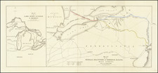
Ohio Before The Toledo War -- A Virtually Unknown Wall Map of Ohio
Rare separately published map of Ohio, shown here on the eve of the Toledo War, which would reshape the northern boundary between Ohio and Michigan Territory.
This is one of the earliest printed wall maps of Ohio, preceded only by slightly smaller 1815 Hough & Bourne map entitled to A Map of the State of Ohio from Actual Survey, published by John Melish.
The map exhibits significant advancements from the Hough & Bourne, relying upon the work of John Kilbourne, whose smaller 1822 map of Ohio is generally considered the most important map of Ohio in the 1820s. In fact, Chapin credits Kilbourne with the following note:
The Publishers of this Map are much indebted to M. John Kilbourne, of Columbus for much valuable information, and for the use of his excellent Gazetteer of the State, to ?? in defining the proper courses or the Streams, Roads, Canals, & the position of the Villages & Townships.
The first and most obvious improvement is the addition of a number of new roads by Chapin and the significant improvement in the naming and depiction of the numerous areas reserved for Native Americans, as well as the addition of numerous towns, especially in the western part of the state. The addition of the National Road, Ohio & Erie Canal and branches, along with several proposed canals is also noteworthy. A number of counties are also now subdivided into townships, most notably in the southwest.
The advancement is well illustrated by looking at the town of Springfield, in Clark County, which has gone from a simple crossroads to a hub that includes that National Road and a total of 10 roads radiating outward in all directions. The cartographic detail around Sandusky Bay and islands to the north is also significantly revised and improved.
Toledo War
The map shows Ohio as it existed immediately before the Toledo War, a bloodless boundary dispute between the state of Ohio and the Michigan Territory, which took place from 1835 to 1836. The conflict arose over the Toledo Strip, a narrow 468-square-mile region located at the western end of Lake Erie, rich in transportation potential and economic promise due to its strategic position.
The origins of the dispute date back to the Northwest Ordinance of 1787, which established the initial boundaries for Ohio and the Michigan Territory. Conflicting surveys, such as those conducted by William Harris for Ohio in 1817 and John A. Fulton for Michigan in 1827, led to overlapping territorial claims. As Michigan Territory progressed toward statehood, the issue of the Toledo Strip became more pressing.
Tensions escalated in early 1835 when Ohio Governor Robert Lucas and Michigan Territorial Governor Stevens T. Mason each mobilized militias to assert control over the area. The situation intensified on April 26, 1835, with the "Battle of Phillips Corner," a skirmish where Michigan militiamen confronted Ohio surveyors, leading to minor injuries but no fatalities. In response, Michigan enacted the Pains and Penalties Act, criminalizing Ohioan authority in the disputed region.
President Andrew Jackson, seeking to maintain peace and order, appointed Benjamin Chew Howard of Maryland to head a commission to resolve the conflict. Despite efforts at mediation, the dispute continued until June 15, 1836, when Congress intervened by passing a compromise. Ohio was awarded the Toledo Strip, and Michigan was compensated with the western Upper Peninsula, a region rich in timber, copper, and iron ore.
This resolution significantly impacted Michigan's path to statehood, which it achieved on January 26, 1837, as the 26th state of the Union. Key figures in this conflict included Ohio's Governor Robert Lucas, Michigan's "Boy Governor" Stevens T. Mason, and U.S. President Andrew Jackson. The final boundary established by this compromise not only defined the geographic limits but also influenced the economic development of both Ohio and Michigan. The Upper Peninsula's abundant natural resources contributed to Michigan's prosperity and industrial growth in the subsequent decades.
Rarity
The present map is virtually unknown to bibliographers, although Karrow identifies the map in Volume 2, page 314 of Checklist of Printed Maps of the Middle West to 1900. The example identified by Karrow appears to be from the Ohio History Connection (formerly the Ohio Historical Society).
Other than the example noted by Karrow, we were unable to locate another example.
William Chapin (1802-1888) was a well-regarde engraver based in New York and Philadelphia during the early 19th century.
Chapin began as an apprentice to John Vallance in the Philadelphia firm Tanner, Vallance, Kearny & Company in 1817. This firm was renowned for its extensive cartographic work, including Tanner's early maps and atlases. Chapin purchased his freedom from Vallance for $125 in 1822.
Following his apprenticeship, Chapin established opened in own printimng business. His large Ornamental Map of the United States, which is considered the first American-published map to be engraved on steel. This innovation marked a significant advancement in the precision and durability of mapmaking.
Around 1839, Chapin transitioned from engraving to a role as Commissioner of Public Schools in New York. This career change marked the beginning of his deep involvement in education, particularly focusing on teaching blind children.
Chapin's most impactful work occurred at the Overbrook School for the Blind, where he made significant strides in educational methods for the blind. He published the first dictionary for the blind, a pioneering work that facilitated better communication and learning for visually impaired students. Chapin's contributions to both the fields of cartography and education for the blind have left a lasting legacy, reflecting his versatility and commitment to improving societal resources through his various roles.


![(Ohio Western Reserve) [1825 Connecticut Western Reserve Land Agreement, between Joshua Stow and Abijah S. Barnum, with Manuscript Plat Map]](https://storage.googleapis.com/raremaps/img/small/82629.jpg)

![(Cincinnati Lettersheet Map) Map of Cincinnati and its environs From Survey by R. H. Rickey [includes a manuscript letter about Cincinnati by Joseph Dana, Jr.]](https://storage.googleapis.com/raremaps/img/small/94090.jpg)