|
||

|

|
|

|
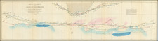
Transvaal on the Eve of the Second Boer War.
Fantastic large-scale map of the Transvaal in 1899, published in Pretoria, South African Republic, and printed in Winterthur, Switzerland by Jakob Schlumpf using his waxed silk chromolithography technique.
The map compiles the surveys filed in the Surveyor General's Office by Friedrich Heinrich Jeppe (1834-1898) and his son Carlos Friedrich Wilhelm (Charles) Jeppe (1870-1900), with the help of Johann Rissik (1857-1925).
The Jeppes began working on the map as early as 1892 but lacked the benefit of comprehensive triangulation of the territory. This meant that the work of mapmaking took years of compilation of block surveys, sketch inspections, and a few astronomically-fixed positions, as opposed to strictly scientific surveying. "Nonetheless, it was superior to anything else available, and the British duly seized on the first shipment of some 5000 map sheets in Cape Town in January 1900." (Lindsay Frederick Braun, Royal Commission, 1903, page 452.)
Apparently, the map was originally planned to comprise only the bottom three sheets. However, additional information became available in 1898 and resulted in the expansion of the project. In fact, F.H. Jeppe, who was a Transvaal official but also a British agent, sent a copy or copies of the bottom three sheets to London via Cape Town. As a result of this, Lt. Col. Henderson, a Cape Town-based intelligence officer, was able to acquire the maps under the guise of seizure as contraband, to avoid a diplomatic incident.
Friedrich Jeppe became severely ill during the production of the map. He died in 1898 of a liver ailment, and the work was carried on by Johann Rissik and Charles Jeppe. The latter complete the map in 1899, one year before his own death, and sent away to Switzerland to have it printed.
The Second Boer War began later in 1899 and concluded in 1902 with Britain stamping out resistance and taking control of the whole country.
The map was co-published by Edward Stanford of London.
Edward Stanford (1827-1904) was a prominent British mapmaker and publisher. A native of Holborn in the heart of London, Edward was apprenticed to a printer and stationer at the age of 14. After his first master died, he worked with several others, including Trelawny W. Saunders of Charing Cross. Saunders oversaw young Edward’s early career, ensuring that he became a Fellow of the Royal Geographical Society. Associations with the Society eventually brought Sanders much business and gave him a reputation as a publisher of explorers. As testament to this reputation, the Stanford Range in British Columbia was named for him by John Palliser.
Stanford briefly partnered with Saunders in 1852 before striking out on his own in 1853. He was an agent for the Ordnance Survey, the Admiralty, the Geological Survey, the Trigonometrical Survey of India, and the India Office. He also controlled the maps of the Society for the Diffusion of Useful Knowledge, another lucrative source of income. In 1857, Stanford founded his namesake Geographical Establishment, with Saunders and A. K. Johnston as engravers. Thereafter, Stanford was known for his “library maps”, particularly those of Africa and Asia.
Addresses and Years of Operation:
- 6 Charing Cross, London (1848): Edward Stanford's initial place of employment at Trelawney Saunders' shop.
- 7 and 8 Charing Cross, London (1853): Stanford expanded his shop to these addresses.
- 55 Charing Cross, London (1873): The shop moved to this larger location.
- 12-14 Long Acre, London (1873): Site of the new print works and current flagship store.
- 7 Mercer Walk, London (2019): Stanfords moved to this address, continuing its legacy.
Stanford's work with Chief Cartographer John Bolton, including the 1858 Library Map of Europe, positioned the company as a leader in quality cartography during a time of exploration and colonialism. Their 1862 Library Map of London earned acclaim from the Royal Geographical Society. With the business thriving, Stanford purchased Staunton & Son in 1877 and, upon retiring in 1885, handed over the reins to his son, Edward Stanford II.
As sole agents for Ordnance Survey Maps, the company's influence and reputation grew, culminating in the Stanford’s London Atlas Of Universal Geography, which was presented to Queen Victoria in 1887. The transition into the 20th century saw further integration of retail, print, and cartographic operations at Long Acre.
During World War I, Stanford's became an essential publisher for the War Office. Edward Fraser Stanford took over in 1917, steering the company through the interwar period and innovations, such as the world’s smallest maps in 1922 and the Daily Mail Motor Road Map in 1926.
Withstanding a bombing in WWII, the company continued under the stewardship of John Keith Stanford and was sold to George Philip & Son in 1947. As it adapted to the digital age, Stanfords received the Ordnance Survey Premier Partner status in 2007 and ventured into online mapping and data services.
Stanfords, now an icon for travellers and explorers, has maintained its cultural relevance and retail success well into the 21st century, underpinned by a legacy of entrepreneurial spirit and commitment to cartographic excellence.
![[Orange Free State, Transvaal, Natal and Part of the Cape Colony] Africa do Sul Folha 1 | Estado Livre d'Orange, Natal, e regiones que limitam com o Transvaal e Colonia do Cabo](https://storage.googleapis.com/raremaps/img/small/90963.jpg)
![[ First Modern Map of Southern Africa ] Tabula Moderna Secunde Porcionis Aphricae](https://storage.googleapis.com/raremaps/img/small/66800.jpg)