This item has been sold, but you can enter your email address to be notified if another example becomes available.


|
||

|

|
|

|
Stock# 83902
Description
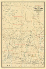
Map of mineral mines in the Kootenays in British Columbia. The Columbia River forms a boundary between the Trail Creek and Nelson Mining Divisions. Gold, silver, copper, lead, and zinc were mined in the two divisions. By 1928, the Rossland Camp in Trail Creek (Le Roi, War Eagle, and Centre Star Gold mines), a source of copper and gold, had closed down due to high water-pumping costs. After that, smaller properties made up most of the mining activity in the division.
Condition Description
Pen annotations on verso. Folding map. Moderating splitting along horizontal centerfold. Minor splitting at extremities of vertical folds.
Reference
http://www.elc.uvic.ca/wordpress/wp-content/uploads/2018/10/MLR-Timeline-ELC-Club-Research-a-thon-Report_2018Feb2.pdf
https://www.miningandenergy.ca/mines/article/lucky_strikes_early_days_in_british_columbias_mining_industry/
Downing, John A., "The Geology and Mineral Deposits of British Columbia" (1948). Bachelors Theses and Reports, 1928 - 1970. Paper 244.
Boivin, John,"Mine exploration company bullish on old Rossland mine properties" (2018). Rossland News.
![[Alaska, Northwest Coast and North Pacific Ocean] Der Noerdliche Theil des Grossenwelt Meeres . . . 1804](https://storage.googleapis.com/raremaps/img/small/80463.jpg)