|
||

|

|
|

|
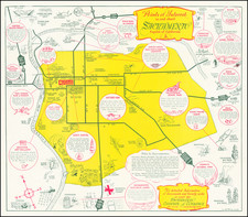
One of the First Printed Maps of Pasadena
Rare separately published Railway Time Table and Map of Pasadena, published by Swerdfiger and Jackson, Job Publishers in Pasadena and Cambell & Marsh of Pasadena as Draghtsmen.
Published only 7 years after the incorporation of Pasadena, the map is centered on Fair Oaks Avenue and Colorado Street, with the Raymond Hotel at the right.
The verso includes a time table for a number of very early Los Angeles Transit Companies, including:
- LA Terminal Railway
- Colorado Street Railway
- Wiley & Greeley's Orange Avenue Bus Line
- Pasadena Street Railway Company
- Highland Street Car Railway
Pasadena was only the second city in Los Angeles County to be incorporated, developing originally as a resort town for eastern visitors coming town on the Atchison, Topeka and Santa Fe Railway. The population of the town grew from 391 in 1880 to about 5,500 as of the date of publication of this map.
Rarity
The map is quite rare. We were unable to locate another example.
19th Century maps of Pasadena are generally very rare. This is the earliest printed map of Pasadena we have offered for sale and only the second 19th Century imprint.
OCLC locates only one earlier map, Cambell & Marsh's 1887 wall map of Pasadena. The original pamphlet promoting the town of Pasadena in 1886 also included a map.
![[ Indio, California ] Thousand and One Things to See and Do in this Fascinating World-Famous Desert Wonderland within and surrounding fabulous Coachella Valley [cover title:] Stay in Indio Date Capital of the U.S.A.](https://storage.googleapis.com/raremaps/img/small/90320.jpg)