|
||

|

|
|

|
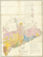
Scarce large folding map of the State of Maine, issued by the Colton firm in 1874.
The map was probably first issued in 1871 during the G.W. & C.B. Colton vogue for large, vibrant folding maps of the states. J.H. Colton issued a similar large map of Maine in the 1850s.
Though the map is scarce today, it was published by the Colton's for around 20 years; Harvard has an example dated 1891.
This is one of the best maps of Maine from the latter half of the 19th century.
G. W. & C. B. Colton was a prominent family firm of mapmakers who were leaders in the American map trade in the nineteenth century. The business was founded by Joseph Hutchins Colton (1800-1893) who bought copyrights to existing maps and oversaw their production. By the 1850s, their output had expanded to include original maps, guidebooks, atlases, and railroad maps. Joseph was succeeded by his sons, George Woolworth (1827-1901) and Charles B. Colton (1831-1916). The firm was renamed G. W. & C. B. Colton as a result. George is thought responsible for their best-known work, the General Atlas, originally published under that title in 1857. In 1898, the brothers merged their business and the firm became Colton, Ohman, & Co., which operated until 1901, when August R. Ohman took on the business alone and dropped the Colton name.
![[Portland & Cape Elizabeth to Moskito Island -- Centered on Kennebec River]](https://storage.googleapis.com/raremaps/img/small/50079.jpg)

![[New England] Tierra Nueva](https://storage.googleapis.com/raremaps/img/small/64626.jpg)