|
||

|

|
|

|
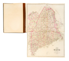
A Fascinating Cadastral Style Map Showing The History of Real Estate Transactions in Maine
Finely executed map of a large swath of Maine (all but the most northerly portions of the state), illustrating the history of Maine's nine major early land transactions, published by Moses Greenleaf.
The map illustrates and labels nine different historical means by which early Maine land owners took title to their land,
- I. Grants by the British Crown and Lords Proprietors of Massachusetts prior to 1692
- II. Lands transferred to early owners by "valid" Indian deeds
- III. Areas showing a mix of British Crown and Massachusetts Proprietors grants and Indian deeds
- IV Grants by the Province of Massachusetts between 1692 and 1785
- V. Conditional Grants by the Province, confirmed after 1785
- VI Conditional Grants from the Province and unconfirmed grants by Indian deeds
- L. Townships sold by lottery in 1787
- B. Townships sold to William Bingham
- M. Lands assigned to the Commonwealth of Massachusetts
The map is drawn from Moses Greenleaf's rare atlas. Thompson notes:
Greenleaf’s atlas is especially important because it is much more than just a compilation of geographical maps. Greenleaf was an ardent supporter of Maine’s claim in the Northeastern Boundary Controversy with Great Britain and the first four maps in the atlas relate to this issue. These are the only maps concerning the dispute to be published in Maine before John Deane’s maps of 1840 and 1842
Over 100 early landowners are noted on the map. The map further notes that"
Townships and Tracts with no mark except their distinguishing number are lands assigned to the State of Maine since the separation.
The upper figures in each township are their respective distinguishing numbers: The lower figures are the number of acres sold in each, excepting the Lottery townships, in which the figures show only the number of acres sold by Lottery. The figures in the tracts marked with Roman numerlas show the number of acres in each tract respectively, as far as can be assertained from the inventories of towns returned to the Legislature in 1820.
Townships and large tracts sold & granted since the year 1783 are distinguished by the names of the principal original Grantees, under the number or designation of the township, or name of the town or plantation.
Rarity
The map is quite rare on the market. AMPR and RBH does not list the map as offered separately.
RBH notes a single example offered at auction in the past 70 years (EV Thompson sale, 2003).
![[ Maine ] Carte Geographique, Statistique et Historique Du Maine](https://storage.googleapis.com/raremaps/img/small/79342.jpg)
![[ Maiune ]. Railroad & Township Map of the State of Maine with Portions of New Hampshire New Brunswick and Canada . . . 1855](https://storage.googleapis.com/raremaps/img/small/100890.jpg)
![[Postal Map of Maine] The Official Map of Maine . . . 1914](https://storage.googleapis.com/raremaps/img/small/83502.jpg)