This item has been sold, but you can enter your email address to be notified if another example becomes available.


|
||

|

|
|

|
Stock# 82783
Description
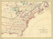
Scarce map of the United States and Mexico, published in 1831.
The map appears shortly after Mexico's Independence, but prior to the Republic of Texas period.
Texas is identifies as a State of Mexico (Coahuila nebst Texas). California is shown as "Unbekantes Land" (Unknown Land), with two large inland Seas shown in Utah (Timpanogos and Teguayo), which include tentatively shown rivers flowing west to the Coast of California. The Missions are named in California, as are most of the Channel Islands.
Oregon is based upon the maps of Lewis & Clark and subsequent early explorers and fur traders, with the Northwest Company Fort shown in the general area of Spokane and Fort Astoria on the mouth of the Columbia River.
Condition Description
Minor foxing.
![Colton's United States Shewing Military Stations, Forts &c. . . . 1861 [Shows Slave, Free and Border States -- Printed For British Market]](https://storage.googleapis.com/raremaps/img/small/103234.jpg)
![[The 13 United States] Charte uber die XIII vereinigte Staaten von Nord-America Entworfen duch F.L. Gussefeld . . . Ao 1784](https://storage.googleapis.com/raremaps/img/small/100144.jpg)