


|
||

|

|
|

|
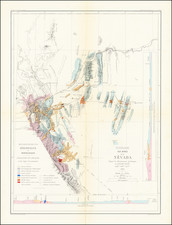
Manuscript map of the gold-bearing deposits of central California during the start of the 20th century. Showing the region between Nevada City and Dutch Flat to the Southwest, the map contains a plethora of contemporaneous information including the distribution of land grants, geological discoveries, and what appears to be the total value of gold extracted in each region.
Particularly interesting on the map is the description in the lower left of an ideal section through a channel. Showing how gravel channels deposited by rivers would have cut into the bedrock, and eventually been overcapped by lava flows, this construction shows how miners would have accessed gold in these regions. The gravels here would have been composed of the bedrock they cut through, and certain qualities would have indicated that they were particularly suitable for mining, notably if they had a bluish color.
The detail on the map is superb, with geologic, topographic, and population information shown throughout. The map is oriented roughly with south at the top of the image. The map was traced on linen by C. Masson in 1930 from a map held in the office of James D. Stewart. It appears that the economic data is unique to this map and was not copied over.
Rarity
The map is known in one other example, held by the University of California, Berkeley. As this is referred to as a "photocopy," it appears that this is also a contemporary replica of the original.
![[ Sonoma County ] Map of Sonoma County California Showing New Boundary Lines of County and Townships, Private Claims and Ranches, Government Townships and Section Lines, Rail Roads and Public Roads Water Works Cities Towns School Districts, etc. Carefully Compiled From The Latest Authorities By R.A. Thompson, County Clerk . . . 1884](https://storage.googleapis.com/raremaps/img/small/99877.jpg)
![[ San Diego County / Julian Mining District ] Sixth Annual Report of the State Mineralogist. Part I for the year ending June 1st 1886.](https://storage.googleapis.com/raremaps/img/small/101709.jpg)
![[Report and] Map of an Exploring Expedition to The Rocky Mountains in the Years 1842 and to Oregon & North California in the Years 1843-44 By Brevet Capt. J. C. Fremont of the Corps of Topographical Engineers . . .](https://storage.googleapis.com/raremaps/img/small/88488.jpg)