


|
||

|

|
|

|
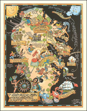
Mapping Joshua Tree National Monument
Scarce early pictorial map of Joshua Tree National Monument (now Joshua Tree National Park) offers a wealth of information, spanning from geographic details to safety and conservation guidelines.
On the front of the map, text annotations provide a historical context, indicating that Native Americans inhabited the area for thousands of years, noting their petroglyphs and pottery remains as points of interest for archaeologists and historians alike. It also references the settlers and prospectors of the mid-1800s who sought riches from the land, underscoring the diverse human history that accompanies the natural landscape.
Safety warnings on the map are clear and emphatic, cautioning against solitary rock climbing and stressing the harshness of the desert environment. Visitors are advised to prepare adequately for the taxing activity of rock scrambling, which carries the risk of injury due to the loose material and sharp surfaces found in the park.
The map's legend is extensive, providing symbols for various trails, including those for hiking and horseback riding, as well as the historical El Camino Real. It marks the boundaries of counties, cities, and the extent of Los Angeles, alongside symbols for gas stations or garages, indicating the infrastructure to support travelers.
On the reverse side, additional details enrich the visitor's understanding of the park. It includes specific advice such as carrying ample water—up to a gallon per day in hot weather—to avoid dehydration, and warnings about the presence of snakes. The map's legends and symbols guide the visitor through the park's extensive network of features, from the iconic Joshua trees and geological formations to designated recreational areas.
The Joshua Tree National Monument, established in 1936 and later redesignated as a national park in 1994, is a region steeped in rich history, both natural and human. The name "Joshua Tree" is attributed to a group of Mormon settlers who crossed the Mojave Desert in the mid-19th century. The tree's unique shape reminded them of a Biblical story in which Joshua reaches his hands up to the sky in prayer.
The area has been inhabited by humans for at least 5,000 years, first by the Pinto people, whose hunter-gatherer culture was succeeded by the Serrano, the Chemehuevi, and eventually the Cahuilla. These groups left behind a rich archaeological record, including rock art, house pits, and stone tools.
In the 1800s, cattle ranchers, miners, and homesteaders moved in, drawn by the prospects of the California gold rush and the allure of the Wild West. The keys to survival in this harsh landscape were knowledge of the land and resourcefulness.
The desert's geology is a story of its own, showcasing a fascinating array of rock formations that were formed more than 100 million years ago. These geological features are the result of the cooling of magma beneath the surface, combined with the force of tectonic plate movements, which have created the region's characteristic boulders and rugged mountains.
Rarity
This is apparently the third edition of the map.
We were unable to locate any other examples.
![[ St. Paul, Minnesota - Harley Davidson ] Route of the Winter Carnival Grande Parade -- Saturday January 27th. 1940 . . . .](https://storage.googleapis.com/raremaps/img/small/102073.jpg)
![[Kensington Metropolitan Park / Kent Lake] Scouting To Adventure Gold Rush of '48 Detroit Area Council Boy Scouts of America . . . 1948](https://storage.googleapis.com/raremaps/img/small/63032.jpg)