


|
||

|

|
|

|
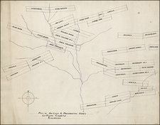
Water Districts 10 & 14. Arkansas River Division Colorado, published by the State Engineer's Office, Colorado, in the years 1904, 1906, and 1908, offers a compelling depiction of early 20th-century hydrological management in the western United States. This intricate document highlights the infrastructure and geography of two significant water districts, primarily focusing on Pueblo and El Paso Counties, key urban centers such as Pueblo, Colorado, and Colorado Springs, and significant geographical features like Pike's Peak.
Water, a crucial resource in the American West and particularly in Colorado, demands significant economic and political management and distribution. The intricate network of irrigation systems that transformed the arid landscapes of Pueblo and El Paso Counties into fertile agricultural lands emerges vividly in Water Districts 10 & 14. Arkansas River Division Colorado. This map testifies to the determination and ingenuity of human engineering in overcoming environmental challenges.
The map places the cities of Pueblo, Colorado, and Colorado Springs prominently, situating the irrigation infrastructure within a human landscape and providing a spatial context to understand the era's urban development and demographic shifts.
Pike's Peak, a geographical landmark with cultural and historical significance, features prominently on this map. Named after American explorer Zebulon Pike, this mountain stands as a symbol of the Western frontier spirit and the expansionist ethos of the era. Its inclusion on the map underscores the majesty and challenges of the terrain that hosted these complex water systems.
In conclusion, Water Districts 10 & 14. Arkansas River Division Colorado stands as a powerful testament to the engineering feats of the early 20th century, offering a rich source of historical and geographical data. This document captures the interplay between human intervention and natural landscape, presenting a snapshot of Colorado's hydrological heritage and the unfolding of its urban and agricultural landscapes.
![(Western Photographs) [Collection of 35 Albumen Photographs by Isaiah Taber, Norman Reed, W.H. Jackson and others: California, Arizona, New Mexico, Colorado]](https://storage.googleapis.com/raremaps/img/small/90506.jpg)
![(Colorado Springs Photograph) [Original cabinet card albumen photograph of Tejon Street, Colorado Springs, looking south toward Cheyenne Mountain]](https://storage.googleapis.com/raremaps/img/small/87515.jpg)
![Nouvelle Carte Du Mexique, Du Texas Et D'Une Partie Des Etats Limitrophes . . . 1840 [Proposed Railroads In Texas -- First Appearance of Arizona on a Printed Map]](https://storage.googleapis.com/raremaps/img/small/103480.jpg)