


|
||

|

|
|

|
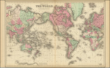
Nice example of Colton's map of the World.
Shows the routes of numerous 18th and 19th century explorers, including Cook, Furneaux, Vancouver, the US/Vincennes voyage, La Perouse, Resolution, etc., with the years of the relevant journey. Colored by countries.
The first signs of the Antarctic Coast are shown. While the world is now taking a nearly final shape, the geopolitical borders are still evolving in this interesting mid-19th century world map.
G. W. & C. B. Colton was a prominent family firm of mapmakers who were leaders in the American map trade in the nineteenth century. The business was founded by Joseph Hutchins Colton (1800-1893) who bought copyrights to existing maps and oversaw their production. By the 1850s, their output had expanded to include original maps, guidebooks, atlases, and railroad maps. Joseph was succeeded by his sons, George Woolworth (1827-1901) and Charles B. Colton (1831-1916). The firm was renamed G. W. & C. B. Colton as a result. George is thought responsible for their best-known work, the General Atlas, originally published under that title in 1857. In 1898, the brothers merged their business and the firm became Colton, Ohman, & Co., which operated until 1901, when August R. Ohman took on the business alone and dropped the Colton name.
![(Apian World Map) La Cosmographia de Pedro Apiano, corregida y añadida por Gemma Frisio ... El Sitio y Descripcion de las Indias y Mundo Nuevo, sacada de la Historia de Francisco Lopez de Gomara, y de la Cosmographia de Ieronymo Giraua Tarragonez [with map:] Mappa Mundi](https://storage.googleapis.com/raremaps/img/small/100234.jpg)