


|
||

|

|
|

|
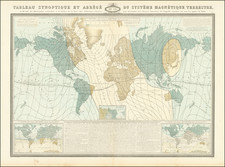
Fantastic and very rare late-19th-century French mappemonde, showing the world with a number of fascinating features, including currents, the heights of principal mountains, distances between cities, exchange rates, and much more. This map was first published in Paris in 1876 or 1877 by Artheme Fayard, and here reissued in a previously unknown 1882 edition.
As already mentioned, the information on this map is extensive and fantastic. One of the most intriguing features is the spiral chart that compares the times at major cities around the world. This chart allows for any time difference to be calculated and is colored to show how the afternoon hours shift as one moves east or west. Next to this chart is a table comparing the heights of all the major mountains in the world, with Mount Everest being shown as the highest. Volcanoes are shown here in eruption.
Some of these tables are of use to the international traveler, with one showing exchange rates for all the major and minor currencies of the world. British currencies are shown from Guineas all the way down to Farthings. Costs of dialing abroad using a telegraph are also included. It is fascinating to see how governments set various tariffs, for example, standardizing rates across territories or states. The most expensive area to dial from France is Argentina, costing nearly five times more than a twenty-word message to New York.
The interesting features in the periphery of the map should not distract from the map itself. The map shows the major surficial currents of the world, as well as distances between major cities. Detail is nearly complete in Arctic Canada, and two polar insets complete these regions. Africa is still shown as uncolonized in the interior, with only coastlines under French control. The geography of some parts is still uncertain, with the course of various rivers shown only with dashes.
The map was apparently first issued in 1877, and used in part as an advertisement to promote Artheme Fayard's Atlas et Geographie Universels . . . The map may actually first date from 1876, giving the BNF's cataloging and an apparent re-engraving of the date, but it is clear that their example was used by some sort of bookseller to advertise both the map and Fayard's Atlas. The map appears to condense much of the information presented in the book, which also contains a table of distances, world map, and polar map.
Rarity
The map is rare on the market. We were unable to locate any dealer or auction records in RBH or AMPR.
OCLC locates one example of an 1877 edition published as an advertisement at the BNF (see the link above) and one example of an 1894 edition.
![[ The Lost Paulus Ageminius Casket Map ]](https://storage.googleapis.com/raremaps/img/small/97534.jpg)
![World [Rand, McNally & Company's Indexed Atlas of the World]](https://storage.googleapis.com/raremaps/img/small/100314.jpg)