|
||

|

|
|

|
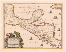
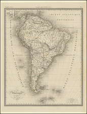
Important early map of South America and the Southern part of North America and the Caribbean by Theodor De Bry, one of the earliest separately published maps of South America.
The map provides one of the best early depictions of South America, reporting the discoveries through the beginning of the final decade of the 16th century. The map is elegantly engraved and embellished with the coats of arms of France and Spain, compass roses, a sailing ship, and sea monsters.
The map bases its cartography on a number of sources. The region around Florida and the Caribbean incorporates de Bry's earlier map of Florida, modeled on an original by Jacques le Moyne. The geography in South America appears to compile various sources, though, according to Burden (80), there is no easily discernible source.
This map originally appeared in De Bry's Grand Voyages, an illustrated collection of accounts of the Americas that defined the early European picture of the New World. This featured in the third part of the text and served to illustrate the voyages of van Staden and de Lery undertaken during the 1540s and 1550s.
The beauty of De Bry's uncommonly intricate ability to engrave masterful maps is evident in this work.
Theodor de Bry (1528-1598) was a prominent Flemish engraver and publisher best known for his engravings of the New World. Born in Liege, de Bry hailed from the portion of Flanders then controlled by Spain. The de Brys were a family of jewelers and engravers, and young Theodor was trained in those artisanal trades.
As a Lutheran, however, his life and livelihood were threatened when the Spanish Inquisition cracked down on non-Catholics. De Bry was banished and his goods seized in 1570. He fled to Strasbourg, where he studied under the Huguenot engraver Etienne Delaune. He also traveled to Antwerp, London, and Frankfurt, where he settled with his family.
In 1590, de Bry began to publish his Les Grands Voyages, which would eventually stretch to thirty volumes released by de Bry and his two sons. The volumes contained not only important engraved images of the New World, the first many had seen of the geographic novelties, but also several important maps. He also published a collection focused on India Orientalis. Les Grands Voyages was published in German, Latin, French, and English, extending de Bry’s fame and his view of the New World.
![[ British Colonies in North America & Caribbean ] L'Amerique Angloise, ou Description des Isles et Terres du Roi d'Angleterre dans l'Amerique, Avec de nouvelles Carte de chaque Isle & Terres](https://storage.googleapis.com/raremaps/img/small/102812.jpg)