|
||

|

|
|

|
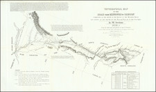
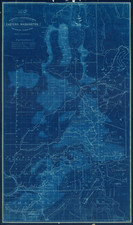
Early Map and Report Covering Yellowstone and the Goblin Mountains with a Magnificent View of Mammoth Hot Springs
This map is roughly centered on Yellowstone Lake and shows the "Hoodoo" or Goblin Mountain to the east of the park.
Hoodoo or Goblin Mountain was named for the giant rocks that jut up to 60 feet in the air and have a ghostly appearance.
The map shows the "Route of Exploration" commissioned by Superintendent Philetus W. Norris from the Indian Lodges just outside of the eastern park boundary to the Hot Springs.
The map is accompanied the Annual Report Of The Superintendent Of The Yellowstone National Park To The Secretary Of The Interior For The Year 1880. The 68-page annual report includes 3 single-page plates and an attractive folding view of Mammoth Hot Springs (11.5 x 6.4").
In 1877, Philetus W. Norris became the second superintendent of Yellowstone National Park. Norris hired Harry Yount to control poaching and vandalism in the park,. When Norris arrived in 1877, there were approximately 32 miles of roads and 108 miles of trails. By the time he left in 1882, there were over 150 miles of roads and over 200 miles of trails.
As Superintendent of Yellowstone, Norris published five annual reports. This report, Norris's fourth, discusses various explorations, the Hoodoo region, Gallatin Range, Madison Plateau, Mount Stephens Trail Route, the Grand Canon of the Yellowstone, Yellowstone Lake, roads, bridges, trails, geysers, springs, fossil forests, the trail and proposed road along the Canon of the Middle Gardiner River. It also covers gold and silver mines, the boundaries of the park, the Crow Indian Treaty, wildlife (including bears), Liberty Cap, the Bannock Indians, Aborigines of the Park, timber, climate, the Natural Bridge at Bridge Creek, and Mammoth Hot Springs. Norris also describes his intentions to support recommendations set forth by the "gamekeeper" (Harry Yount), etc.
The report includes a detailed history of Yellowstone National Park. Appendices include the report of the Gamekeeper, Harry Yount; an act to set apart a certain tract of land lying near the headwaters of the Yellowstone River as a public park; rules and regulations of the park; an appeal to all to desist from vandalism of any kind to the park; chart of weather for 1880; and chart showing distances of roads and trails in the park.
![[Wall Map of Jackson Hole and Environs] Grand Teton National Park Wyoming - Teton Country 1968](https://storage.googleapis.com/raremaps/img/small/99906.jpg)