|
||

|

|
|

|
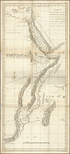
One of the Most Interesting African Thematic Maps Ever Published.
Fantastic original antique map showing Germany colonial explorations in East Africa. This plate shows four separate maps, each highlighting a different geographical aspect of the region.
These maps were produced based on the research compiled during Dr. Franz Stuhlmann's travels to East Africa and published in 1894. Stuhlmann's research epitomized German interests in the scientific exploration of Africa in its attempt to catalog all facets of the region, from its peoples to its geology, animal life, and vegetation.
The main map shows the distributions of five main ethnic groups, which are further divided into subgroups. The terms used for these North African and Horn of Africa peoples are certainly outdated, but they include the Bantu, Niloten (People of the Nile), Hamiten (Descendants of Ham), Zwergvolker (Dwarf people), and Swahili-Kustenbevolkerung. The distribution of certain traits (such as circumcision) are also demarcated.
Dr. Stuhlmann was evidently able to trace the expansion of some of the Bantu population of the region, which he notes with red arrows.
The largest inset, in the lower left, shows the geology of the area, including eleven different types of strata. The majority of the ground rock here is Granite or pre-Cambrian gneiss, and this area is now defined by the East African Rift.
The map in the upper right shows the types of vegetation present in the area. Interestingly, it shows the boundaries where certain crops, including cash crops like coffee or oil palms, can grow.
The final inset, in the upper left, shows a map of population distribution across the region.
Dr. Franz Stuhlmann
Franz Stuhlmann was a zoology graduate of the University of Wurzburg who received funding to study the small animals of East Africa in 1888. However, the Arab Uprising called him into military service soon after, and he was involved in several assaults on positions. He was shot in the leg during the conflict.
After the uprising, Stuhlmann was able to lead a larger twenty-six-month expedition starting in April 1890 which involved over four hundred people. He traveled extensively over this time, visiting large swaths of Kenya, Uganda, and Tanzania. At the end of his expedition in 1892, he returned to Germany to write a report, from which the present map is drawn.
Franz Ludwig Stuhlmann was a German naturalist, zoologist and African explorer, born in Hamburg.
Stuhlmann studied natural sciences at Tübingen and Freiburg. Concentrating on zoology, he also undertook studies at the University of Kiel before being employed as a demonstrator at the Zoological Institute of Würzburg in 1887.
After studying at Tübingen and Freiburg, he went to East Africa in 1888, and during the revolt of the Arabs in 1890 entered the German corps of defense as a lieutenant, and was severely wounded at Lembula.
After his recovery he joined the expedition of Emin Pasha to the lake region, was sent ahead from Undussuma to Lake Victoria, and reached the coast in July, 1892, at Bagamoyo, whence he returned to Germany with valuable cartographic material and rich collections, to which he added copiously on another trip to German East Africa, undertaken in 1893-94 by order of the government. In 1908-10 he was secretary of the Colonial Institute in Hamburg.
![(Tangiers, Tzaffin, Ceuta, Arzila, and Sala) Tingis Lusitanis Tangiara. . . [on sheet with] Tzaffin [and] Salaa [and] Arzilla
[and] Septa](https://storage.googleapis.com/raremaps/img/small/54983mp2.jpg)